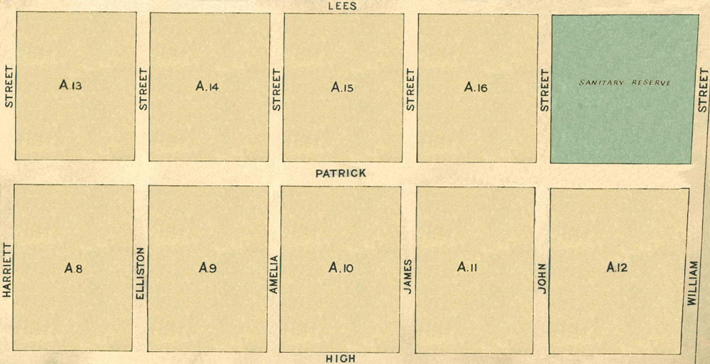
Map 1 - Sections A8 to A17
The information in these reports provides a timeline of occurrences for each property up to 1919, including details such as conveyances and occupancy. Compiled from records at the Tasmanian Archives, the Land Titles Office, Hobart Town Gazette Valuation Rolls, and newspaper articles, this is a work in progress and will be continually updated.
All sections below have been modified from the Tasmanian Archives: Map - Bothwell B37, AF819/1/26
View original map on the Tasmanian Archives website https://libraries.tas.gov.au/Digital/AF819-1-26
[A8] Patrick Street - 9a 0r 6p
Bounded on the East by eleven chains and thirty links southerly along Elliston Street from its angle with Patrick Street; on the South by eight chains westerly along Franklin Street; on the West by eleven chains and thirty links northerly along Harriett Street to Patrick Street aforesaid; and thence on the North by eight chains easterly along that street to the point of commencement - 9 acres, 6 perches.
Land Grant: 27 Nov 1861, Richard Sims, in consideration of £21 (RD1: Richard Sims, p46/1861, https:/libraries.tas.gov.au/Digital/RD1-1-51/RD1-1-51P046JPG)
Land Grant: 28 Jan 1862, Richard Sims, enrolled, upon payment of £21 (RD1: Richard Sims, p46/1861, https:/libraries.tas.gov.au/Digital/RD1-1-51/RD1-1-51P046JPG)
Conveyed: 27 Feb 1863, Richard Sims to William Roylance for £100 (LIST: Richard Sims, historic deed, no 05/1717)
Residence: 17 Nov 1863, William Roylance (owner, occupier), house, annual rateable value £10 (TGG: "Valuation Roll," 1863, p2130-2131, https:/www.familysearch.org/ark:/61903/3:1:3QS7-998F-V992-K)
Residence: 15 Nov 1864, William Roylance (owner, occupier), house, annual rateable value £10 (TGG: "Valuation Roll," 1864, p2078-2079, https:/www.familysearch.org/ark:/61903/3:1:3QSQ-G98F-V3JQ)
Residence: 1867, William Roylance, shoemaker (MCPD: 1867-68, p64, image 122, https:/nla.gov.au/nla.obj-3027675771/view)
Residence: 26 Feb 1867, William Roylance (owner, occupier), house, annual rateable value £10 (TGG: "Valuation Roll," 1867, p468-469, https:/www.familysearch.org/ark:/61903/3:1:3QS7-L98F-V3G3)
Residence: 7 Feb 1871, William Roylance (owner, occupier), house, annual rateable value £10 (TGG: "Valuation Roll," 1871, p188-189, https:/www.familysearch.org/ark:/61903/3:1:3QS7-L98F-K951)
Advertisement: 16 Mar 1871, William Roylance named under "Real Property Act Notices" (MERC: "Real Property Act Notices," 16 Mar 1871, https:/trove.nla.gov.au/newspaper/article/8867404)
Conveyed: bef 24 Apr 1871, William Roylance to John White; a deed has not been located (LIST: John White, title historic, vol 11, fol 199)
Certificate of Title: 24 Apr 1871, registered to John White, storekeeper (LIST: John White, title historic, vol 11, fol 199)
Residence: 30 Jan 1877, Zacharias Smith (occupier), John White (owner), house, paddock, annual rateable value £3 (TGG: "Valuation Roll," 1877, p190-191, https:/www.familysearch.org/ark:/61903/3:1:3QS7-898F-KVDW)
Residence: 19 Mar 1878, Michael Quinn (occupier), Thomas Sheen (owner), house, annual rateable value £5 4s (TGG: "Valuation Roll," 1878, p494-495, https:/www.familysearch.org/ark:/61903/3:1:3QS7-898F-J97X-7)
Residence: 25 Feb 1879, Michael Quinn (occupier), Thomas Sheen (owner), house, annual rateable value £5 4s (TGG: "Valuation Roll," 1879, p374-375, https:/www.familysearch.org/ark:/61903/3:1:3QS7-998N-9SXR)
Conveyed: 10 May 1879, John White to Thomas Sheen for £55 (LIST: John White, title historic, vol 11, fol 199)
Certificate of Title: 20 Oct 1879, registered to Thomas Sheen, shepherd (LIST: Thomas Sheen, title historic, vol 27, fol 49)
Conveyed: 13 Nov 1883, Thomas Sheen to William Henry Ellis for £60 (LIST: Thomas Sheen, title historic, vol 27, fol 49)
Certificate of Title: 18 Dec 1883, registered to William Henry Ellis, merchant (LIST: William Henry Ellis, vol 40, fol 165)
Residence: 23 Jun 1885, Zacharias Smith (occupier, inserted), William Henry Ellis (owner), house, annual rateable value £7 (TGG: "Valuation Roll," 1885, p860-861, https:/www.familysearch.org/ark:/61903/3:1:3QS7-898N-S3MW)
Residence: 28 Mar 1899, John Hoskinson (occupier), Ellis and Son (owner), house, capital value £150, annual rateable value £9 (TGG: "Valuation Roll," 1899, p324-325, https:/www.familysearch.org/ark:/61903/3:1:3QSQ-G98F-V8FR)
Conveyed: 19 Sep 1904, William Henry Ellis to John James Cooper for £50 (LIST: William Henry Ellis, vol 40, fol 165)
Certificate of Title: 29 Sep 1904, registered to John James Cooper, labourer (LIST: John James Cooper, title historic, vol 143, fol 153)
Residence: 21 Nov 1905, John James Cooper (owner, occupier), cottage, capital value £150, annual rateable value £9 (TGG: "Valuation Roll," 1925, p1630, https:/www.familysearch.org/ark:/61903/3:1:3QS7-L98N-SF9)
[A10] Patrick Street - 9a 0r 6p
Bounded on the North by eight chains westerly along Patrick Street from its angle with James Street; on the West by eleven chains and thirty links southerly along Amelia Street; on the South by eight chains easterly along Franklin Street to James Street aforesaid; and thence on the East by eleven chains and thirty links northerly along that street to the point of commencement - 9 acres, 6 perches.
Land Grant: 14 May 1866, John White, in consideration of £22 (RD1: John White, p127/1866, https:/libraries.tas.gov.au/Digital/RD1-1-59/RD1-1-59P127JPG)
Land Grant: 18 May 1866, John White, enrolled upon payment of £22 (RD1: John White, p127/1866, https:/libraries.tas.gov.au/Digital/RD1-1-59/RD1-1-59P127JPG)
Land: 26 Feb 1867, John White (owner), allotment, 9 acres, annual rateable value £2 (TGG: "Valuation Roll," 1867, p470-471, https:/www.familysearch.org/ark:/61903/3:1:3QSQ-G98F-VQ9C)
Land: 19 Mar 1878, John White (owner), allotments, 44 acres, annual rateable value £19 10s; includes [2], [A2], [A3], [Aa2] (TGG: "Valuation Roll," 1878, p496-497, https:/www.familysearch.org/ark:/61903/3:1:3QS7-898F-J97K-M)
Property Transfer: 28 Nov 1904, Estate of John White to his daughter-in-law, Beatrice Edith (North) White (PROB: John White, no 6477/1904, https:/libraries.tas.gov.au/Digital/ad960-1-27-6477)
Certificate of Title: 10 Mar 1905, registered to Beatrice Edith (North) White, married woman (LIST: Beatrice Edith White, vol 146, fol 53)
[A13] Patrick Street - 8a 0r 0p
Bounded on the North by eight chains easterly along Lees Street from its angle with Harriett Street; on the East by ten chains southerly along Elliston Street; on the South by eight chains westerly along Patrick Street to Harriett Street aforesaid; and thence on the West by ten chains northerly along that street to the point of commencement - 8 acres.
Land Grant: 28 Oct 1857, John Merry Jnr, granted in consideration of £20 (RD1: John Merry, p178/1858, https:/libraries.tas.gov.au/Digital/RD1-1-38/RD1-1-38P176JPG)
Land Grant: 8 Feb 1858, John Merry Jnr, enrolled upon payment of £20 (RD1: John Merry, p178/1858, https:/libraries.tas.gov.au/Digital/RD1-1-38/RD1-1-38P176JPG)
Land: 18 May 1858, John Merry Jnr & James Merry (owners), annual rateable value £4 (TGG: "Valuation Roll," 1858, p698-699, https:/www.familysearch.org/ark:/61903/3:1:3QS7-898F-VZZ3)
Land: 21 Dec 1858, John Merry Jnr & James Merry (owners), annual rateable value £4 (TGG: "Valuation Roll," 1858, p1543, https:/www.familysearch.org/ark:/61903/3:1:3QS7-L98F-VRP8)
Land: 21 Dec 1858, Frederick Rout (occupier, inserted), John Merry Jnr & James Merry (owners), annual rateable value £4 (TGG: "Valuation Roll," 1858, p1544-1545, https:/www.familysearch.org/ark:/61903/3:1:3QSQ-G98F-VTGT)
Land: 19 Nov 1861, John Merry Jnr & James Merry (owners), allotment, annual rateable value £2 (TGG: "Valuation Roll," 1861, p1694-1695, https:/www.familysearch.org/ark:/61903/3:1:3QS7-898F-J93K-Z)
Conveyed: bef 30 Aug 1866, John Merry Jnr & James Merry to William Maskell; a deed has not been located (LIST: William Maskell, title historic, vol 6, fol 74)
Certificate of Title: 30 Aug 1866, registered to William Maskell, licensed victualler (LIST: William Maskell, title historic, vol 6, fol 74)
Land: 26 Feb 1867, William Maskell (owner), arable land, 17 acres, annual rateable value £8; includes [A4-A5] (TGG: "Valuation Roll," 1867, p468-469, https:/www.familysearch.org/ark:/61903/3:1:3QS7-L98F-V3G3)
Land: 11 Feb 1868, William Maskell (owner), arable land, 17 acres, annual rateable value £6; includes [A4-A5] (TGG: "Valuation Roll," 1868, p224-225, https:/www.familysearch.org/ark:/61903/3:1:3QS7-898F-JT5Z)
Land: 19 Mar 1878, William Maskell (owner), arable land, 17 acres, annual rateable value £6; includes [A4-A5] (TGG: "Valuation Roll," 1878, p494-495, https:/www.familysearch.org/ark:/61903/3:1:3QS7-898F-J97X-7)
Conveyed: 14 Aug 1885, Executors of William Maskell to Hector McRae for £38 (LIST: William Maskell, title historic, vol 6, fol 74)
Certificate of Title: 6 Oct 1885, registered to Hector McRae, farmer (LIST: Hector McRae, title historic, vol 49, fol 47)
Land: 14 Jan 1890, Hector McRae (owner), land, 17 acres, annual rateable value £8; includes [A4-A5] (TGG: "Valuation Roll," 1890, p174-175, https:/www.familysearch.org/ark:/61903/3:1:3QS7-L98F-VD5K)
Conveyed: 16 Aug 1895, Hector McRae to Sarah Hodgson Lovell for £50 (LIST: Hector McRae, title historic, vol 49, fol 47)
Certificate of Title: 26 Aug 1895, registered to Sarah Hodgson Lovell, spinster (LIST: Sarah Hodgson Lovell, title historic, vol 96, fol 179)
Land: 28 Mar 1899, William Blake (occupier), Miss Sarah Lovell (owner), paddock, capital value £80, annual rateable value £3 (TGG: "Valuation Roll," 1899, p324-325, https:/www.familysearch.org/ark:/61903/3:1:3QSQ-G98F-V8FR)
Conveyed: 4 Jul 1899, Sarah Hodgson Lovell to William Henry Sealy by endorsement (LIST: Sarah Hodgson Lovell, title historic, vol 96, fol 179)
[A14] Patrick Street - 8a 0r 0p
Bounded on the East by ten chains southerly along Amelia Street from its angle with Lees Street; on the South by eight chains westerly along Patrick Street; on the West by ten chains northerly along Elliston Street to Lees Street aforesaid; and thence on the North by eight chains easterly along that street to the point of commencement - 8 acres.
Land Grant: 2 May 1862, James Harcourt, in consideration of £20 (RD1: James Harcourt, p193/1862, https:/libraries.tas.gov.au/Digital/RD1-1-51/RD1-1-51P194JPG)
Land Grant: 28 May 1862, James Harcourt, enrolled upon payment of £20 (RD1: James Harcourt, p193/1862, https:/libraries.tas.gov.au/Digital/RD1-1-51/RD1-1-51P194JPG)
Land: 15 Nov 1864, George William Ife (occupier), James Harcourt (owner), allotment, annual rateable value £2 (TGG: "Valuation Roll," 1864, p2076-2077, https:/www.familysearch.org/ark:/61903/3:1:3QS7-898F-V3K4)
Land: 26 Feb 1867, George William Ife (occupier), James Harcourt (owner), allotment, annual rateable value £2 (TGG: "Valuation Roll," 1867, p466-467, https:/www.familysearch.org/ark:/61903/3:1:3QS7-898F-V3LK)
Land: 11 Feb 1868, George William Ife (occupier), James Harcourt (owner), allotment, annual rateable value £2 (TGG: "Valuation Roll," 1868, p222-223, https:/www.familysearch.org/ark:/61903/3:1:3QSQ-G98F-JYMR)
Land: 7 Feb 1871, George William Ife (occupier), James Harcourt (owner), allotment, annual rateable value £2 (TGG: "Valuation Roll," 1871, p186-187, https:/www.familysearch.org/ark:/61903/3:1:3QS7-L98F-KSSD)
Land: 19 Mar 1878, George William Ife (occupier), James Harcourt (owner), allotment, annual rateable value £2 (TGG: "Valuation Roll," 1878, p494-495, https:/www.familysearch.org/ark:/61903/3:1:3QS7-898F-J97X-7)
Advertisement: 4 Apr 1879, "Bothwell-Valuable Store" Well fenced allotment (MERC: "Bothwell-Valuable Store," 4 Apr 1879, https:/trove.nla.gov.au/newspaper/article/8975502)
Conveyed: 7 May 1879, James Harcourt to Joseph Smith for £15 (LIST: James Harcourt, historic deed, no 06/5498)
Land: 14 Jan 1890, Joseph Smith (owner), 8 acres, annual rateable value £2 (TGG: "Valuation Roll," 1890, p176-177, https:/www.familysearch.org/ark:/61903/3:1:3QS7-898F-VD2J)
Land: 28 Mar 1899, Joseph Smith (owner), 8 acres, capital value £24, annual rateable value £2 (TGG: "Valuation Roll," 1899, p326-327, https:/www.familysearch.org/ark:/61903/3:1:3QS7-998F-V4YV)
[A15] Patrick Street - 8a 0r 0p
Bounded on the North by eight chains westerly along Lees Street from its angle with James Street; on the West by ten chains southerly along Amelia Street; on the South by eight chains easterly along Patrick Street to James Street aforesaid; and thence on the East by ten chains northerly along that street to the point of commencement - 8 acres.
Land Purchase Grant:14 May 1866, Simon Arnett, enrolled upon payment of £20 (LIST: Simon Arnett, land grant historic, vol 8, fol 86)
Conveyed: 11 Sep 1866, Simon Arnett to Samuel Jackson for £25 (LIST: Simon Arnett, land grant historic, vol 8, fol 86)
Certificate of Title: 4 Feb 1867, registered to Samuel Jackson, labourer (LIST: Samuel Jackson, title historic, vol 6, fol 187)
Land: 26 Feb 1867, Samuel Jackson (owner), allotment, annual rateable value £2 (TGG: "Valuation Roll," 1867, p468-469, https:/www.familysearch.org/ark:/61903/3:1:3QS7-L98F-V3G3)
Land: 11 Feb 1868, Samuel Jackson (owner), allotment, annual rateable value £2 (TGG: "Valuation Roll," 1868, p224-225, https:/www.familysearch.org/ark:/61903/3:1:3QS7-898F-JT5Z)
Land: 1 Mar 1870, Samuel Jackson (owner), allotment, annual rateable value £2 (TGG: "Valuation Roll," 1870, p358-359, https:/www.familysearch.org/ark:/61903/3:1:3QS7-L98F-VBQV)
Land: 7 Feb 1871, Samuel Jackson (owner), allotment, annual rateable value £2 (TGG: "Valuation Roll," 1871, p186-187, https:/www.familysearch.org/ark:/61903/3:1:3QS7-L98F-KSSD)
Land: 11 Mar 1873, Samuel Jackson (owner), allotment, annual rateable value £4 (TGG: "Valuation Roll," 1873, p250-251, https:/www.familysearch.org/ark:/61903/3:1:3QS7-L98F-VV7M)
Land: 19 Mar 1878, Samuel Jackson (owner), allotment, annual rateable value £4 10s (TGG: "Valuation Roll," 1878, p494-495, https:/www.familysearch.org/ark:/61903/3:1:3QS7-898F-J97X-7)
Land: 14 Jan 1890, Samuel Jackson (owner), annual rateable value £2 (TGG: "Valuation Roll," 1890, p174-175, https:/www.familysearch.org/ark:/61903/3:1:3QS7-L98F-VD5K)
Land: 28 Mar 1899, Samuel Jackson (owner), bushland, capital value £20, annual rateable value £1 (TGG: "Valuation Roll," 1899, p324-325, https:/www.familysearch.org/ark:/61903/3:1:3QSQ-G98F-V8FR)
Property Transfer: 1 Mar 1900, Estate of Samuel Jackson to his sons, Samuel Jackson & John Jackson (PROB: Samuel Jackson, no 5570/1900, https:/libraries.tas.gov.au/Digital/AD960-1-23-5570)
Land: 21 Nov 1905, Samuel Jackson (owner), Scrubby Hill, bushland, capital value £20, annual rateable value £1 (TGG: "Valuation Roll," 1905, p1630-1631, https://www.familysearch.org/ark:/61903/3:1:3QS7-L98N-SF9)
[A16] Patrick Street - 8a 0r 0p
Bounded on the North by eight chains easterly along Lees Street from its angle with James Street; on the East by ten chains southerly along John Street; on the South by eight chains westerly along Patrick Street to James Street aforesaid; and thence on the West by ten chains northerly along that street to the point of commencement - 8 acres.
Land Grant: 9 Apr 1866, Simon Arnett, enrolled upon payment of £20 (LIST: Simon Arnett, land grant historic, vol 8, fol 65)
Land: 26 Feb 1867, Simon Arnett (owner), allotment, annual rateable value £2 (TGG: "Valuation Roll," 1867, p465, https:/www.familysearch.org/ark:/61903/3:1:3QS7-998F-VS6C)
Land: 8 Sep 1874, William Nobes (occupier, erased), Simon Arnett (owner), annual rateable value £1 (TGG: "Valuation Roll," 1874, p897, https:/www.familysearch.org/ark:/61903/3:1:3QS7-898F-JBPR)
Land: 8 Sep 1874, Simon Arnett (owner, inserted), annual rateable value £1 (TGG: "Valuation Roll," 1874, p897, https:/www.familysearch.org/ark:/61903/3:1:3QS7-898F-JBPR)
Land: 19 Mar 1878, Simon Arnett (owner, inserted), annual rateable value £1 (TGG: "Valuation Roll," 1878, p493, https:/www.familysearch.org/ark:/61903/3:1:3QS7-898F-J97V-D)
Mortgage: 18 Mar 1880, Simon Arnett borrowed £300 from Frederick Synnot; includes [H3], [I8.1], [A16], [Gg2], [Xx-Yy] (LIST: Simon Arnett, land grant historic, vol 8, fol 65)
Mortgage: 18 Nov 1885, upon the death of Frederick Synnot, the mortgage and Certificate of Title were transferred to his Executors (LIST: Simon Arnett, land grant historic, vol 8, fol 65)
Land: 16 Feb 1886, Simon Arnett (owner), paddock, annual rateable value £1 (TGG: "Valuation Roll," 1886, p429, https:/www.familysearch.org/ark:/61903/3:1:3QS7-898F-29B)
Mortgage: 11 Apr 1889, executors of Frederick Synnot transferred the mortgage to the Perpetual Trustees, Executors and Agency Company of Tasmania Limited (LIST: Simon Arnett, land grant historic, vol 8, fol 65)
Land: 14 Jan 1890, Simon Arnett (owner), 26 acres, annual rateable value £8; includes [H3], [Gg2], [Xx-Yy] (TGG: "Valuation Roll," 1890, p173, https:/www.familysearch.org/ark:/61903/3:1:3QS7-898F-VDGQ)
Land: 28 Mar 1899, William Blake (occupier), Perpetual Trustees, Executors and Agency Co (owners), land, 26 acres, capital value £200, annual rateable value £9; includes [H3], [Gg2], [Xx-Yy] (TGG: "Valuation Roll," 1899, p323, https:/www.familysearch.org/ark:/61903/3:1:3QS7-L98F-V8X4)
Bibliography of Sources
LIST - Tasmania: The List: Properties & Titles. Historic Deeds, Grants & Titles. Images. Land Information System Tasmania. Tasmanian Government. Australia. https://www.thelist.tas.gov.au : 2023.
MCPD - TROVE: MacPhail's Directory of Tasmania 1867-68. Images. National Library of Australia. https://nla.gov.au/nla.obj-3027675771/view : 2025.
MERC - TROVE: The Mercury (Hobart, TAS : 1860-1954). Images. National Library of Australia. https://trove.nla.gov.au : 2023.
PROB - Libraries Tasmania: Copies of Wills Recording Granting of Probate, 1825-1989 (AD960). Images. Probate Registry (TA1574). Tasmanian Government, Australia. https://www.libraries.tas.gov.au/tasmanian-archives : 2023.
RD1 - Libraries Tasmania: Deeds of Land Grants 1832-1935 (RD1). Images. Registry of Deeds (TA84). Tasmanian Government, Australia. https://libraries.tas.gov.au/tasmanian-archives : 2023.
TGG - FamilySearch: Australia, Tasmania, Government Gazette, 1833-1925. Images. Tasmanian Archive and Heritage Office, Hobart. https://www.familysearch.org/search/collection/2170647 : 2023.