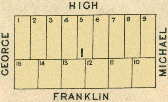
Map 1 - Section I
The information in these reports provides a timeline of occurrences for each property up to 1919, including details such as conveyances and occupancy. Compiled from records at the Tasmanian Archives, the Land Titles Office, Hobart Town Gazette Valuation Rolls, and newspaper articles, this is a work in progress and will be continually updated.
All map sections below have been modified from the Tasmanian Archives: Map - Bothwell B37, AF819/1/26
View original map on the Tasmanian Archives website https://libraries.tas.gov.au/Digital/AF819-1-26
[I1-I3] High Street - 3a 3r 33p
[I1] - Bounded on the North by one hundred and seven links along High Street; on the West by three chains along George Street; on the South by one hundred and seven links along allotment No 15; and thence on the East by three chains along allotment No 2 to High Street aforesaid - 1 rood, 11 perches.
[I2] - Lot 2 - Bounded on the North by one hundred and seven links along High Street; on the West by three chains along allotment No 1; on the South by one hundred and seven links along allotment No’s 15 and 14 respectively; and on the East by three chains along allotment No 3 to High Street aforesaid - 1 rood, 11 perches.
[I3] - Bounded on the North by one hundred and seven links along High Street; on the West by three chains along allotment No 2; on the South by one hundred and seven links along allotment No 14; and on the East by three chains along allotment No 4 to High Street aforesaid - 1 rood, 11 perches.
Land Grant: 9 Jul 1838, Frederick Synnot, in consideration of £10 10s (RD1: Frederick Synnot, p68/1838, https:/libraries.tas.gov.au/Digital/RD1-1-14/RD1-1-14P68JPG)
Article: 27 Jul 1838, [I1], William Stanley Sharland named under "Title Deeds." It appears William Stanley Sharland did not take up the land grant; the next record for this block of land is the purchase by Joseph Thorogood on 15 Feb 1840. A conveyance has not been located between William Stanley Sharland and Joseph Thorogood (HTC: "Lands Sold," 27 Jul 1838, https:/trove.nla.gov.au/newspaper/article/4163335)
Article: 27 Jul 1838, [I2-I3], Frederick Synnot named under "Title Deeds" (HTC: "Title Deeds," 27 Jul 1838, https:/trove.nla.gov.au/newspaper/article/4163335)
Conveyed: 15 Feb 1840, Joseph Thorogood (LIST: Joseph Thoroughgood, historic deed, no 03/0992)
Land Grant: 6 Apr 1840, [I1], Joseph Thorogood, in consideration of £5 12s 6p (RD1: Joseph Thoroughgood, p87/1843, https:/libraries.tas.gov.au/Digital/RD1-1-16/RD1-1-16P87JPG)
Census:1 Jan 1842, [I1], Joseph Thorogood (owner, occupier), wood house, completed (CEN1: Joseph Thoroughgood, p235/1842, https:/libraries.tas.gov.au/Digital/CEN1-1-2-235)
Census:1 Jan 1842, [I1], William Mawson (owner, occupier), wood house, unfinished, inhabited (CEN1: William Mawson, p215/1842, https:/libraries.tas.gov.au/Digital/CEN1-1-2-215)
Land Grant: 19 Sep 1842, [I2-I3], Frederick Synnot, enrolled upon payment of £10 10s (RD1: Frederick Synnot, p68/1838, https:/libraries.tas.gov.au/Digital/RD1-1-14/RD1-1-14P68JPG)
Conveyed: 17 Nov 1843, [I1], William Mawson paid Joseph Thorogood £10 for a share in the property (LIST: Joseph Thoroughgood, historic deed, no 03/0992)
Land Grant: 23 Nov 1843, [I1], Joseph Thorogood, enrolled upon payment of £5 12s 6p (RD1: Joseph Thoroughgood, p87/1843, https:/libraries.tas.gov.au/Digital/RD1-1-16/RD1-1-16P87JPG)
Conveyed: 18 Jun 1845, [I1], Joseph Thorogood & William Mawson to Joshua Jennings; paid William Mawson £25; Joseph Thorogood, 5s (LIST: Joseph Thoroughgood, historic deed, no 03/0992)
Conveyed: 23 Jul 1857, [I1-I2], Frederick Synnot to John Bale for £30 (LIST: John Bale, historic deed, no 04/4587)
Conveyed: 30 Dec 1857, [I1], Joshua Jennings to John Bale for £40 (LIST: John Bale, historic deed, no 04/5544)
The following information refers to [I1-I3] High St.
Land: 18 May 1858, John Bale (owner), cultivated land, annual rateable value £1 (TGG: "Valuation Roll," 1858, p696-697, https:/www.familysearch.org/ark:/61903/3:1:3QS7-L98F-VZVR)
Land: 19 Nov 1861, John Bale (owner), annual rateable value £1 (TGG: "Valuation Roll," 1861, p1693, https:/www.familysearch.org/ark:/61903/3:1:3QSQ-G98F-J9Q6-B)
Land: 15 Nov 1864, John Bale (owner), cultivated land, annual rateable value £1 (TGG: "Valuation Roll," 1864, p2076-2077, https:/www.familysearch.org/ark:/61903/3:1:3QS7-898F-V3K4)
Land: 26 Feb 1867, John Bale (owner), cultivated land, annual rateable value £1 10s (TGG: "Valuation Roll," 1867, p466-467, https:/www.familysearch.org/ark:/61903/3:1:3QS7-898F-V3LK)
Article: 27 Jan 1870, John Bale named under "Real Property Act Notices" (MERC: "Real Property Act Notices," 7 Jan 1870, https:/trove.nla.gov.au/newspaper/article/8864563)
Conveyed: aft 19 Feb 1870, John Bale to Simon Arnett; a deed has not been located (LIST: Simon Arnett, title historic, vol 10, fol 133)
Land: 1 Mar 1870, Simon Arnett (owner), 5 acres, annual rateable value £5; includes [J6-J10], [L8-L9] (TGG: "Valuation Roll," 1870, p355, https:/www.familysearch.org/ark:/61903/3:1:3QS7-L98F-VBWF)
Certificate of Title: 19 Mar 1870, registered to Simon Arnett, storekeeper (LIST: Simon Arnett, title historic, vol 10, fol 133)
Land: 19 Mar 1878, Simon Arnett (owner), barn, 2 acres, annual rateable value £2; includes [L8-L9] (TGG: "Valuation Roll," 1878, p493, https:/www.familysearch.org/ark:/61903/3:1:3QS7-898F-J97V-D)
Conveyed: 15 Jul 1878, Simon Arnett to William Branch for £75 (LIST: Simon Arnett, title historic, vol 10, fol 133)
Residence: 16 Feb 1886, William Branch (owner, occupier), house, annual rateable value £8 (TGG: "Valuation Roll," 1886, p429, https:/www.familysearch.org/ark:/61903/3:1:3QS7-898F-29B)
Residence: 24 Feb 1891, William Branch (owner, occupier), house, annual rateable value £8 (TGG: "Valuation Roll," 1891, p485, https:/www.familysearch.org/ark:/61903/3:1:3QSQ-G98N-9QYK)
Residence: 28 Mar 1899, William Branch (owner, occupier), cottage, capital value £150, annual rateable value £7 10s (TGG: "Valuation Roll," 1899, p324-325, https://www.familysearch.org/ark:/61903/3:1:3QSQ-G98F-V8FR)
[I4] High Street - 0a 1r 11p
Bounded on the North by one hundred and seven links along High Street; on the West by three chains along allotment No 3; on the South by one hundred and seven links along allotment No 13; and thence on the East by three chains along allotment No 5 to High Street - 1 rood, 11 perches.
Land Grant: 9 Jul 1838, John Colbeck, in consideration of £5 (RD1: John Colbeck, p123/1842, https:/libraries.tas.gov.au/Digital/RD1-1-15/RD1-1-15P124JPG)
Article: 27 Jul 1838, John Colbeck named under "Title Deeds" (HTC: "Title Deeds," 27 Jul 1838, https:/trove.nla.gov.au/newspaper/article/4163335)
Census:1 Jan 1842, John Colbeck, (owner, occupier), brick house, completed (CEN1: John Colbeck, p219/1842, https:/libraries.tas.gov.au/Digital/CEN1-1-2-219)
Article: 24 Aug 1842, John Colbeck named under "Title Deeds" (LAEX: "Title Deeds," 24 Aug 1842, https:/trove.nla.gov.au/newspaper/article/36249698)
Land Grant: 3 Jul 1843, John Colbeck, enrolled upon payment of £5 (RD1: John Colbeck, p123/1842, https:/libraries.tas.gov.au/Digital/RD1-1-15/RD1-1-15P124JPG)
Residence: 18 May 1858, John Colbeck (owner, occupier), house, annual rateable value £18 (TGG: "Valuation Roll," 1858, p696-697, https:/www.familysearch.org/ark:/61903/3:1:3QS7-L98F-VZVR)
Residence: 26 Feb 1867, John Colbeck (owner, occupier), house, annual rateable value £15 (TGG: "Valuation Roll," 1867, p466-467, https:/www.familysearch.org/ark:/61903/3:1:3QS7-898F-V3LK)
Residence: 1 Mar 1870, John Colbeck (owner, occupier), house, garden, annual rateable value £15 (TGG: "Valuation Roll," 1870, p356-357, https:/www.familysearch.org/ark:/61903/3:1:3QS7-L98F-VB3M)
Residence: 7 Feb 1871, John Colbeck (owner, occupier), house, garden, annual rateable value £15 (TGG: "Valuation Roll," 1871, p186-187, https:/www.familysearch.org/ark:/61903/3:1:3QS7-L98F-KSSD)
Conveyed: 25 Mar 1873, John & Elizabeth Colbeck conveyed their property to George & Alfred Ibbott, but kept the legal right to receive six shillings per week from the land for the rest of their lives (and the survivor’s life), after which the obligation ended. (LIST: John Colbeck, historic deed, no 05/9097)
Residence: 19 Mar 1878, Mrs Elizabeth Colbeck (occupier), George & Alfred Ibbott (owners), house, annual rateable value £10. The owner is stated to be John Ibbott for the next 13 years, but there is no record of the land being conveyed to him by his sons. (TGG: "Valuation Roll," 1878, p494-495, https:/www.familysearch.org/ark:/61903/3:1:3QS7-898F-J97X-7)
Residence: 27 Jan 1880, Mrs Elizabeth Colbeck (occupier), George & Alfred Ibbott (owners), house, annual rateable value £10 (TGG: "Valuation Roll," 1880, p92-93, https:/www.familysearch.org/ark:/61903/3:1:3QS7-998N-9SFV)
Residence: 17 Feb 1885, Mrs Elizabeth Colbeck (occupier), George & Alfred Ibbott (owners), house, annual rateable value £10 (TGG: "Valuation Roll," 1885, p304-305, https:/www.familysearch.org/ark:/61903/3:1:3QSQ-G98N-S9XC)
Residence: 23 Jun 1885, Mrs Elizabeth Colbeck (occupier, erased), George & Alfred Ibbott (owners), house, annual rateable value £10 (TGG: "Valuation Roll," 1885, p860-861, https:/www.familysearch.org/ark:/61903/3:1:3QS7-898N-S3MW)
Residence: 23 Jun 1885, Unoccupied (inserted), George & Alfred Ibbott (owners), house, annual rateable value £10 (TGG: "Valuation Roll," 1885, p860-861, https:/www.familysearch.org/ark:/61903/3:1:3QS7-898N-S3MW)
Residence: 16 Feb 1886, John Medhurst (occupier), George & Alfred Ibbott (owners), house, annual rateable value £10 (TGG: "Valuation Roll," 1886, p430-431, https:/www.familysearch.org/ark:/61903/3:1:3QS7-998F-2XV)
Residence: 21 Feb 1888, Frederick Cooper (occupier), Alfred Ibbott (owner), house, annual rateable value £10 (TGG: "Valuation Roll," 1888, p400-401, https:/www.familysearch.org/ark:/61903/3:1:3QS7-L98F-JLTX)
Residence: 14 Jan 1890, David Morrison (occupier), Alfred Ibbott (owner), house, annual rateable value £10 (TGG: "Valuation Roll," 1890, p174-175, https:/www.familysearch.org/ark:/61903/3:1:3QS7-L98F-VD5K)
Residence: 28 Mar 1899, Mrs Margaret Hunt (occupier), George William & Alfred Ibbott (owners), cottage, garden, capital value £140, annual rateable value £9 (TGG: "Valuation Roll," 1899, p324-325, https:/www.familysearch.org/ark:/61903/3:1:3QSQ-G98F-V8FR)
Residence: 14 Jan 1902, Mrs Elizabeth Hoskinson (occupier), Ibbott Bros (owners), cottage, garden, capital value £140, annual rateable value £10 (TGG: "Valuation Roll," 1902, p70-71, https:/www.familysearch.org/ark:/61903/3:1:3QS7-998F-KLJ8)
[I5] High Street - 0a 1r 11p
Bounded on the East by three hundred links southerly along Lot 6 purchased from the Crown by Charles Thorpe commencing at the north-west angle thereof on High Street and extending to Lot 12 purchased from the Crown by H Jones; on the South by one hundred and seven links westerly along the last mentioned land and Lot 13 purchased from the Crown by the said H Jones to Lot 4 purchased from the Crown by John Colbeck; on the West by three hundred links northerly along the last mentioned land to High Street aforesaid; and thence on the North by one hundred and seven links easterly along that street to the point of commencement - 1 rood, 11 perches.
Article: 27 Jul 1838, John Thomson named under "Title Deeds" (HTC: "Title Deeds," 27 Jul 1838, https:/trove.nla.gov.au/newspaper/article/4163335)
Article: 18 Jul 1842, John Thomson named under "Title Deeds" (LAEX: "Title Deeds," 24 Aug 1842, https:/trove.nla.gov.au/newspaper/article/36249698)
Land Grant: aft 18 Jul 1842, John Thomson; a record of this has not been located (RD1: John Thomson, Bothwell Land Grant Map, B37/AF819-1-26, https:/libraries.tas.gov.au/Digital/AF819-1-26)
Conveyed: bef 18 May 1858, John Thomson to Richard Hill; a deed has not been located (LIST: John Richard Hill, historic deed, no 13/9453)
Residence: 18 May 1858, Mrs James Ward (occupier), Richard Hill (owner), house, ground, annual rateable value £14 (TGG: "Valuation Roll," 1858, p700, https:/www.familysearch.org/ark:/61903/3:1:3QS7-898F-VZH5)
Residence: 20 Nov 1860, Unoccupied, Richard Hill (owner), house, ground, annual rateable value £10 (TGG: "Valuation Roll," 1860, p1882-1883, https:/www.familysearch.org/ark:/61903/3:1:3QS7-L98F-VQGX)
Residence: 19 Nov 1861, Samuel Pitt (occupier), Richard Hill (owner), house, ground, annual rateable value £10 8s (TGG: "Valuation Roll," 1860, p1884-1885, https:/www.familysearch.org/ark:/61903/3:1:3QS7-L98F-VQYQ)
Property Transfer: aft 11 Dec 1862, Estate of Richard Hill to his widow, Sarah (Bale) Hill (LIST: John Richard Hill, historic deed, no 13/9453)
Residence: 15 Nov 1864, Mrs Sarah Hill (owner, occupier), house, ground, annual rateable value £10 (TGG: "Valuation Roll," 1864, p2076-2077, https:/www.familysearch.org/ark:/61903/3:1:3QS7-898F-V3K4)
Residence: 26 Feb 1867, Mrs Sarah Hill (owner, occupier), house, ground, annual rateable value £10 (TGG: "Valuation Roll," 1867, p466-467, https:/www.familysearch.org/ark:/61903/3:1:3QS7-898F-V3LK)
Residence: 1 Mar 1870, Empty, Mrs Sarah Ainsworth (owner), house, ground, annual rateable value £10 (TGG: "Valuation Roll," 1870, p356-357, https:/www.familysearch.org/ark:/61903/3:1:3QS7-L98F-VB3M)
Residence: 16 Feb 1886, Alfred Ainsworth (occupier), Mrs Sarah Ainsworth (owner), house, annual rateable value £9 (TGG: "Valuation Roll," 1886, p429, https:/www.familysearch.org/ark:/61903/3:1:3QS7-898F-29B)
Residence: 14 Jan 1890, Alfred Ainsworth (occupier), Mrs Sarah Ainsworth (owner), house, annual rateable value £9 (TGG: "Valuation Roll," 1890, p173, https:/www.familysearch.org/ark:/61903/3:1:3QS7-898F-VDGQ)
Residence: 28 Mar 1899, Alfred Ainsworth (occupier), Mrs Sarah Ainsworth (owner), house, annual rateable value £8 (TGG: "Valuation Roll," 1899, p323, https:/www.familysearch.org/ark:/61903/3:1:3QS7-L98F-V8X4)
Residence: 2 Aug 1910, Mrs Sarah Ainsworth (owner, occupier), cottage, capital value £120, annual rateable value £8 (TGG: "Valuation Roll," 1910, p826-827, https:/www.familysearch.org/ark:/61903/3:1:3QSQ-G98N-SSHF)
Conveyed: 5 Oct 1916, John Richard Hill & Louisa Maria (Hill) Davie conveyed to Ethel Kate Best for £60 (LIST: John Richard Hill, historic deed, no 13/9453)
Conveyed: 15 Apr 1918, Ethel Kate (Best) Shaw to her mother, Susan Mary (Marshall) Best, with natural love and affection (LIST: Ethel Kate Best, historic deed, no 14/2460)
Residence: 4 Mar 1919, Mrs Susan Best (owner, occupier), cottage, annual rateable value £10 (TGG: "Valuation Roll," 1919, p492-493, https:/www.familysearch.org/ark:/61903/3:1:3QS7-898N-SQ1F)
[I6] High Street - 0a 1r 11p
Bounded on the North by one hundred and seven links along High Street; on the West by three chains along allotment No 5; on the South by one hundred and seven links along allotment No 12; and thence on the East by three chains along allotment No 7 to High Street aforesaid - 1 rood, 11 perches.
Land Grant: 9 Jul 1838, Charles Thorpe, in consideration of £5 10s (RD1: Charles Thorpe, p151/1855, https:/libraries.tas.gov.au/Digital/RD1-1-31/RD1-1-31P151JPG)
Article: 27 Jul 1838, Charles Thorpe named under "Title Deeds" (HTC: "Title Deeds," 27 Jul 1838, https:/trove.nla.gov.au/newspaper/article/4163335)
Land Grant: 6 Aug 1855, Charles Thorpe, enrolled upon payment of £5 10s (RD1: Charles Thorpe, p151/1855, https:/libraries.tas.gov.au/Digital/RD1-1-31/RD1-1-31P151JPG)
Conveyed: 1 Feb 1856, Charles Thorpe to Francis Knowles for £20 (LIST: Charles Thorpe, historic deed, no 04/2441)
Residence: 18 May 1858, Aaron Patient (occupier), Francis Knowles (owner), house, annual rateable value £6 (TGG: "Valuation Roll," 1858, p698-699, https:/www.familysearch.org/ark:/61903/3:1:3QS7-898F-VZZ3)
Residence: 20 Nov 1860, John Cooper (occupier), Francis Knowles (owner), house, annual rateable value £6 (TGG: "Valuation Roll," 1860, p1882-1883, https:/www.familysearch.org/ark:/61903/3:1:3QS7-L98F-VQGX)
Residence: 15 Nov 1864, Francis Knowles (owner, occupier), house, annual rateable value £6 (TGG: "Valuation Roll," 1864, p2076-2077, https:/www.familysearch.org/ark:/61903/3:1:3QS7-898F-V3K4)
Residence: 26 Feb 1867, Francis Knowles (owner, occupier), house, ground, annual rateable value £8 (TGG: "Valuation Roll," 1867, p468-469, https:/www.familysearch.org/ark:/61903/3:1:3QS7-L98F-V3G3)
Residence: 11 Feb 1868, William Taylor (occupier), Francis Knowles (owner), house, ground, annual rateable value £8 (TGG: "Valuation Roll," 1868, p226-227, https:/www.familysearch.org/ark:/61903/3:1:3QS7-898F-JTLY)
Conveyed: 20 Mar 1868, Francis Knowles to Rampling John Bale; a conveyance was never executed (LIST: Frank Pilcher, historic deed, no 12/0774)
Residence: 1 Mar 1870, Richard Shepherd (occupier), Rampling John Bale (owner), house, ground, annual rateable value £6 10s (TGG: "Valuation Roll," 1870, p358-359, https:/www.familysearch.org/ark:/61903/3:1:3QS7-L98F-VBQV)
Residence: 20 Feb 1872, Richard Shepherd (occupier), Rampling John Bale (owner), house, ground, annual rateable value £8 (TGG: "Valuation Roll," 1872, p408-409, https:/www.familysearch.org/ark:/61903/3:1:3QS7-898F-J9MW-Y)
Residence: 8 Sep 1874, William Dalby (occupier, erased), Rampling John Bale (owner), house, annual rateable value £5 (TGG: "Valuation Roll," 1874, p897, https:/www.familysearch.org/ark:/61903/3:1:3QS7-898F-JBPR)
Residence: 8 Sep 1874, Alfred Ainsworth (occupier, inserted), Rampling John Bale (owner), cottage, annual rateable value £5 (TGG: "Valuation Roll," 1874, p897, https:/www.familysearch.org/ark:/61903/3:1:3QS7-898F-JBPR)
Residence: 25 Feb 1879, Alfred Ainsworth (occupier), Rampling John Bale (owner), cottage, annual rateable value £5 (TGG: "Valuation Roll," 1879, p371, https:/www.familysearch.org/ark:/61903/3:1:3QS7-L98N-9S2L)
Residence: 27 Jan 1880, Alfred Ainsworth (occupier), Rampling John Bale (owner), house, annual rateable value £5 (TGG: "Valuation Roll," 1880, p91, https:/www.familysearch.org/ark:/61903/3:1:3QSQ-G98N-9SGF)
Residence: 28 Mar 1899, Mrs Christina Page (occupier), Rampling John Bale (owner), cottage, capital value £40, annual rateable value £3 (TGG: "Valuation Roll," 1899, p326-327, https:/www.familysearch.org/ark:/61903/3:1:3QS7-998F-V4YV)
Conveyed: 31 Dec 1907, Rampling John Bale to Frank Pilcher; a conveyance was never executed (LIST: Frank Pilcher, historic deed, no 12/0774)
Land: 2 Aug 1910, Frank Pilcher (owner), land, capital value £180, annual rateable value £12 (TGG: "Valuation Roll," 1910, p828-829, https:/www.familysearch.org/ark:/61903/3:1:3QS7-898N-SSQP)
[I7-I9] High Street - 0a 3r 33p
[I7] - Bounded on the North by one hundred and seven links along High Street; on the West by three chains along allotment No 6; on the South by one hundred and seven links along allotment No 11; and thence on the East by three chains along allotment No 8 - 1 rood, 11 perches.
[I8] - Bounded on the North by one hundred and seven links along High Street; on the West by three chains along allotment No 7; on the South by one hundred and seven links along allotment No 11 and 10 respectively; and thence on the East by three chains along allotment No 9 - 1 rood, 11 perches.
[I9] - Bounded on the North by one hundred and seven links along High Street; on the West by three chains along allotment No 8; on the South by one hundred and seven links along allotment No 10 to Michael Street; and thence on the East by three chains along Michael Street aforesaid to its angle with High Street - 1 rood, 11 perches.
Land Grant: 9 Jul 1838, John McRa, in consideration of £16 10s (RD1: John McRa, p131/1842, https:/libraries.tas.gov.au/Digital/RD1-1-14/RD1-1-14P131JPG)
Article: 27 Jul 1838, John McRa named under "Title Deeds" (HTC: "Title Deeds," 27 Jul 1838, https:/trove.nla.gov.au/newspaper/article/4163335)
Land Grant: 22 Sep 1842, John McRa, enrolled upon payment of £16 10s (RD1: John McRa, p131/1842, https:/libraries.tas.gov.au/Digital/RD1-1-14/RD1-1-14P131JPG)
Conveyed: 20 Jan 1844, Henry Wilkinson, permanent assignee of the estate and effects of John McRa, to James Gill for £16; includes [H7-H8] (LIST: James Gill, historic deed, no 02/6917)
Conveyed: 17 Jan 1849, James Gill to Thomas Hale for £17 (LIST: James Gill, historic deed, no 03/4186)
Residence: 18 May 1858, Thomas Hale (owner, occupier), house, annual rateable value £15; includes [J2] (TGG: "Valuation Roll," 1858, p696-697, https:/www.familysearch.org/ark:/61903/3:1:3QS7-L98F-VZVR)
Residence: 20 Nov 1860, Thomas Hale (owner, occupier), house, annual rateable value £15; includes [J2] (TGG: "Valuation Roll," 1860, p1882-1883, https:/www.familysearch.org/ark:/61903/3:1:3QS7-L98F-VQGX)
Residence: 19 Nov 1861, Thomas Hale (owner, occupier), house, annual rateable value £16; includes (TGG: "Valuation Roll," 1861, p1694-1695, https:/www.familysearch.org/ark:/61903/3:1:3QS7-898F-J93K-Z)
Residence: 15 Nov 1864, Thomas Hale (owner, occupier), house, annual rateable value £15 (TGG: "Valuation Roll," 1864, p2076-2077, https:/www.familysearch.org/ark:/61903/3:1:3QS7-898F-V3K4)
Residence: 26 Feb 1867, Thomas Hale (owner, occupier), house, annual rateable value £15 (TGG: "Valuation Roll," 1867, p466-467, https:/www.familysearch.org/ark:/61903/3:1:3QS7-898F-V3LK)
Residence: 11 Feb 1868, Thomas Hale (owner, occupier), house, annual rateable value £15 (TGG: "Valuation Roll," 1868, p222-223, https:/www.familysearch.org/ark:/61903/3:1:3QSQ-G98F-JYMR)
Conveyed: bef 7 May 1869, 1r 11p, Thomas Hale to Henry Craig for £25 (LIST: Henry Craig, title historic, vol 9, fol 140)
For more information, go to [I7] High St and [I8-I9] High St
[I7] High Street - 0a 1r 11p
Bounded on the North by one chain seven links westerly along High Street commencing at a point distant two chains and fourteen links from the angle of the street with Michael Street; on the West by three chains southerly along Lot 6; on the South by one chain and seven links easterly along Lot 11; and on the East by three chains northerly along Lot 8 belonging to Thomas Hale to the point of commencement - 1 rood, 11 perches. (1)
Conveyed: bef 7 May 1869, Thomas Hale to Henry Craig for £25 (LIST: Henry Craig, title historic, vol 9, fol 140)
Certificate of Title: 7 May 1869, registered to Henry Craig, wood carter (LIST: Henry Craig, title historic, vol 9, fol 140)
Residence: 1 Mar 1870, Henry Craig (owner, occupier), house, garden, annual rateable value £10 (TGG: "Valuation Roll," 1870, p356-357, https:/www.familysearch.org/ark:/61903/3:1:3QS7-L98F-VB3M)
Residence: 19 Mar 1878, Henry Craig (owner, occupier), house, annual rateable value £10 (TGG: "Valuation Roll," 1878, p494-495, https:/www.familysearch.org/ark:/61903/3:1:3QS7-898F-J97X-7)
Residence: 25 Feb 1879, Henry Craig (owner, occupier), house, annual rateable value £10 (TGG: "Valuation Roll," 1879, p372-373, https:/www.familysearch.org/ark:/61903/3:1:3QS7-998N-9SKG)
Property Transfer: 24 Dec 1889, Estate of Henry Craig to his son, Charles William Craig (PROB: Henry Craig, no 3780/1889, https:/libraries.tas.gov.au/Digital/AD960-1-18-3780)
Residence: 14 Jan 1890, Mrs Julia Craig (owner, occupier), house, annual rateable value £10 (TGG: "Valuation Roll," 1890, p174-175, https:/www.familysearch.org/ark:/61903/3:1:3QS7-L98F-VD5K)
Residence: 28 Mar 1899, Mrs Julia Craig (owner, occupier), house, capital value £120, annual rateable value £9 (TGG: "Valuation Roll," 1899, p324-325, https:/www.familysearch.org/ark:/61903/3:1:3QSQ-G98F-V8FR)
Conveyed: 12 Nov 1915, Charles William Craig to Luke Evans, he being the person appointed by writing under the hand of Charles William Craig, the devisee of the Will of the late Henry Craig dated May 29, 1889 (LIST: Henry Craig, title historic, vol 9, fol 140)
Certificate of Title: 19 Nov 1915, registered to Luke Evans, butcher (LIST: Luke Evans, title historic, vol 235, fol 200)
[I8-I9] High Street - 0a 2r 22p
[I8] - Bounded on the North by one hundred and seven links along High Street; on the West by three chains along allotment No 7; on the South by one hundred and seven links along allotment No 11 and 10 respectively; and thence on the East by three chains along allotment No 9 - 1 rood, 11 perches.
[I9] - Bounded on the North by one hundred and seven links along High Street; on the West by three chains along allotment No 8; on the South by one hundred and seven links along allotment No 10 to Michael Street; and on the East by three chains along Michael Street aforesaid to its angle with High Street - 1 rood, 11 perches.
Residence: 1 Mar 1870, Thomas Hale (owner, occupier), house, annual rateable value £15 (TGG: "Valuation Roll," 1870, p356-357, https:/www.familysearch.org/ark:/61903/3:1:3QS7-L98F-VB3M)
Residence: 7 Feb 1871, Thomas Hale (owner, occupier), house, annual rateable value £14 (TGG: "Valuation Roll," 1871, p186-187, https:/www.familysearch.org/ark:/61903/3:1:3QS7-L98F-KSSD)
Residence: 3 Feb 1874, Thomas Hale (owner, occupier), house, annual rateable value £14 (TGG: "Valuation Roll," 1874, p208-209, https:/www.familysearch.org/ark:/61903/3:1:3QSQ-G98F-J9MR-G)
Article: 25 Sep 1874, [I8.1], Thomas Hale named under "Real Property Act Notices" (MERC: "Real Property Act Notices," 25 Sep 1874, https:/trove.nla.gov.au/newspaper/article/8932439)
Conveyed: bef 13 Nov 1874, [I8.1], Thomas Hale to Simon Arnett; a deed has not been located (LIST: Simon Arnett, title historic, vol 16, fol 182)
For more information, go to [I8.1] High St and [I9.1] High St
[I8.1] High Street - 0a 1r 5½p
Bounded on the North by ninety-five links westerly along High Street commencing at a point distant one chain and nineteen links from the angle of that street with Michael Street; on the West by three chains southerly along Lot 7; on the South by ninety-five links easterly along Lots 10 and 11; and thence on the East by three chains northerly along land belonging to Thomas Hale to the point of commencement - 1 rood, 5½ perches.
Advertisement: 25 Sep 1874, Thomas Hale named under "Real Property Act Notices" (MERC: "Real Property Act Notices," 25 Sep 1874, https:/trove.nla.gov.au/newspaper/article/8932439)
Conveyed: bef 13 Nov 1874, Thomas Hale to Simon Arnett; a deed has not been located (LIST: Simon Arnett, title historic, vol 16, fol 182)
Certificate of Title: 13 Nov 1874, registered to Simon Arnett (LIST: Simon Arnett, title historic, vol 16, fol 182)
Mortgage: 18 Mar 1880, Simon Arnett borrowed £300 from Frederick Synnot against [H3], [I8.1], [A16], [Gg2], [Xx-Yy] (LIST: Simon Arnett, title historic, vol 16, fol 182)
Mortgage: 18 Nov 1885, transferred to the executors Frederick Synnot (LIST: Simon Arnett, title historic, vol 16, fol 182)
Mortgage: 1 Dec 1885, discharged, £300 paid in full by Simon Arnett (LIST: Simon Arnett, title historic, vol 16, fol 182)
Conveyed: 31 Mar 1886, Simon Arnett to John Hale for £30 (LIST: Simon Arnett, title historic, vol 16, fol 182)
Certificate of Title: 19 Jun 1886, registered to John Hale, bootmaker (LIST: John Hale, title historic, vol 52, fol 120)
Land: 14 Jan 1890, John Hale (owner), annual rateable value 10s (TGG: "Valuation Roll," 1890, p174-175, https:/www.familysearch.org/ark:/61903/3:1:3QS7-L98F-VD5K)
Conveyed: 1 Jan 1891, John Hale to Robert Edward Blake (LIST: John Hale, title historic, vol 52, fol 120)
Residence: 28 Mar 1899, Robert Blake (owner, occupier), cottage, garden, capital value £250, annual rateable value £13 (TGG: "Valuation Roll," 1899, p324-325, https:/www.familysearch.org/ark:/61903/3:1:3QSQ-G98F-V8FR)
Electoral Roll: 1914, Robert Edward Blake, carter; Mary Ann Elizabeth Blake, domestic duties (ELEC: p2-3/1914, https:/www.ancestry.com.au/imageviewer/collections/1207/images/RDAUS1901_100678__0007-00853)
Residence: 3 Nov 1914, Robert Edward Blake (owner, occupier), cottage, annual rateable value £13 (TGG: "Valuation Roll," 1914, p2008-2009, https:/www.familysearch.org/ark:/61903/3:1:3QS7-L98N-977Y)
Land: 3 Nov 1914, Robert Edward Blake (owner), allotment, annual rateable value £1 (TGG: "Valuation Roll," 1914, p2008-2009, https:/www.familysearch.org/ark:/61903/3:1:3QS7-L98N-977Y)
Electoral Roll: 1919, Robert Edward Blake, carter; Mary Ann Elizabeth Blake, domestic duties (ELEC: p2-3/1919, https:/www.ancestry.com.au/imageviewer/collections/1207/images/RDAUS1901_100682__0007-00929)
Residence: 4 Mar 1919, Robert Edward Blake (owner, occupier), cottage, annual rateable value £13 (TGG: "Valuation Roll," 1919, p492-493, https:/www.familysearch.org/ark:/61903/3:1:3QS7-898N-SQ1F)
[I9.1] High Street - 0a 1r 18p
Bounded on the North by one chain eighteen links westerly along High Street commencing at the angle of Michael Street; on the West by three chains four links southerly along Lot 8; on the South by one chain nineteen links easterly along Lot 10; and thence on the East by three chains six links northerly along Michael Street aforesaid to the point of commencement - 1 rood, 18 perches.
Residence: 19 Mar 1878, Thomas Hale (owner, occupier), house, annual rateable value £10 (TGG: "Valuation Roll," 1878, p494-495, https:/www.familysearch.org/ark:/61903/3:1:3QS7-898F-J97X-7)
Residence: 14 Jan 1890, Edward Hale (occupier) Mrs Jane Hale (owner), house, annual rateable value £10 (TGG: "Valuation Roll," 1890, p174-175, https:/www.familysearch.org/ark:/61903/3:1:3QS7-L98F-VD5K)
Article: 24 Feb 1899, John Hale named under "Applications for Certificate of Title" (MERC: "Applications for Certificate of Title," 24 Feb 1899, https:/trove.nla.gov.au/newspaper/article/9442030)
Residence: 28 Mar 1899, Edward Hale (occupier), executors of Thomas Hale (owners), cottage, capital value £80, annual rateable value £6 (TGG: "Valuation Roll," 1899, p324-325, https:/www.familysearch.org/ark:/61903/3:1:3QSQ-G98F-V8FR)
Certificate of Title: 7 Apr 1899, registered to John Hale, bootmaker (LIST: John Hale, title historic, vol 110, fol 140)
Conveyed: 11 Jul 1899, John Hale to George Horne for £60 (LIST: John Hale, title historic, vol 110, fol 140)
Mortgage: 11 Jul 1899, George Horne borrowed £45 from William Henry Hitchins (LIST: George Horne, title historic, vol 112, fol 30)
Certificate of Title: 22 Jul 1899, registered to George Horne, labourer (LIST: George Horne, title historic, vol 112, fol 30)
Mortgage: 9 Jul 1903, transferred to Sarah Ann Hutchins, widow of William Henry Hutchins (LIST: George Horne, title historic, vol 112, fol 30)
Advertisement: 17 Nov 1903, "Property at Bothwell" Mortgagee default (MERC: "Property at Bothwell," 17 Nov 1903, https:/trove.nla.gov.au/newspaper/article/12257292)
Conveyed: 13 Jun 1906, Sarah Ann Hutchins to Sarah Jane (Whiteway) Triffett for £25, in exercise of the Power of Sale (LIST: George Horne, title historic, vol 112, fol 30)
Certificate of Title: 6 Jul 1906, registered to Sarah Jane (Whiteway) Triffett, widow (LIST: Sarah Jane Triffett, title historic, vol 155, fol 55)
Land: 4 Mar 1919, Robert Edward Blake (occupier), Mrs Sarah Jane Triffett (owner), annual rateable value £2 (TGG: "Valuation Roll," 1919, p492-493, https:/www.familysearch.org/ark:/61903/3:1:3QS7-898N-SQ1F)
[I10-I11] Franklin Street - 0a 2r 22p
[10] - Bounded on the South by one hundred and sixty-one links along Franklin Street; on the West by two chains along allotment No 11; on the North by one hundred and sixty-one links along allotment No's 8 and 9 to Michael Street; and thence on the East by two chains along Michael Street to its angle with Franklin Street - 1 rood, 11 perches.
[11] - Bounded on the South by one hundred and sixty-one links along Franklin St; on the West by two chains along allotment No 2; on the North by one hundred and sixty-one links along allotment No’s 7 and 8; and thence on the East by two chains along allotment No 10 to Franklin St - 1 rood, 11 perches.
Article: 27 Jul 1838, [I10], John Thomson; it appears this title deed wasn't taken up named under "Title Deeds" (HTC: "Title Deeds," 27 Jul 1838, https:/trove.nla.gov.au/newspaper/article/4163335)
Land Grant: 18 Oct 1842, [I10], Charles Thomas Smith, in consideration of £6 15s (RD1: Charles Thomas Smith, p188/1842, https:/libraries.tas.gov.au/Digital/RD1-1-14/RD1-1-14P189JPG)
Land Grant: 14 Nov 1842, [I10], Charles Thomas Smith, upon payment of £6 15s (RD1: Charles Thomas Smith, p188/1842, https:/libraries.tas.gov.au/Digital/RD1-1-14/RD1-1-14P189JPG)
Land Grant: 28 Aug 1867, [I11], Charles Thorpe, enrolled upon payment of £6 (RD1: Charles Thorpe, p117/1867,https:/libraries.tas.gov.au/Digital/RD1-1-14/RD1-1-14P189JPG)
Conveyed: bef 24 Sep 1868, [I10], Charles Thomas Smith to Charlotte (Geldard) Parker; a deed has not been located (MERC: "Real Property Act Notices," 24 Sep 1868, https:/trove.nla.gov.au/newspaper/article/8854687)
Advertisement: 24 Sep 1868, [I10], Charlotte Smith named under "Real Property Act Notices." Presumably, this advertisement was under the name of Charlotte (Geldard) Smith, being the mother of Robert Parker, who was only twenty years of age at the time, as mentioned on the Certificate of Title registered in his name. (MERC: "Real Property Act Notices," 24 Sep 1868, https:/trove.nla.gov.au/newspaper/article/8854687)
Conveyed: bef 29 Oct 1868, [I11], Charles Thorpe to Robert Parker; a deed has not been located (LIST: Robert Parker, title historic, vol 9, fol 39)
- All further information refers to [I10-I11] Franklin St
Certificate of Title: 29 Oct 1868, registered, Robert Parker, an infant of the age of twenty years living in Regents Plains (LIST: Robert Parker, title historic, vol 9, fol 39)
Residence: 7 Feb 1871, Thomas Smith (occupier), Robert Parker (owner), house, annual rateable value £12 (TGG: "Valuation Roll," 1871, p188-189, https:/www.familysearch.org/ark:/61903/3:1:3QS7-L98F-K951)
Mortgage: 31 Jul 1875, Robert Parker borrowed £40 from Henry Dobson (LIST: Robert Parker, title historic, vol 9, fol 39)
Residence: 19 Mar 1878, Thomas Smith (occupier), Robert Parker (owner), house, paddocks, annual rateable value £12; includes [A6] (TGG: "Valuation Roll," 1878, p496-497, https:/www.familysearch.org/ark:/61903/3:1:3QS7-898F-J97K-M)
Mortgage: 19 Mar 1880, discharged, £40 paid in full by Robert Parker (LIST: Robert Parker, title historic, vol 9, fol 39)
Mortgage: 20 Mar 1880, Robert Parker borrowed £50 from the Tasmanian Permanent Building and Investment Society (LIST: Robert Parker, title historic, vol 9, fol 39)
Mortgage: 27 May 1885, Robert Parker borrowed £25 from the Tasmanian Permanent Building and Investment Society (LIST: Robert Parker, title historic, vol 9, fol 39)
Residence: 16 Feb 1886, Thomas Smith (occupier), Robert Parker (owner), house, annual rateable value £12 (TGG: "Valuation Roll," 1886, p432-433, https:/www.familysearch.org/ark:/61903/3:1:3QS7-998F-23D)
Conveyed: 21 Jan 1889, The Tasmanian Permanent Building and Investment Society to Charles Albert Nichols for £80, in exercise of the Power of Sale of Robert Parker (LIST: Robert Parker, title historic, vol 9, fol 39)
Certificate of Title: 19 Feb 1889, registered, Charles Albert Nichols, carpenter (LIST: Charles Albert Nichols, title historic, vol 66, fol 119)
Residence: 14 Jan 1890, Joseph Burdon (occupier), Charles Albert Nichols (owner), house, annual rateable value £6 10s (TGG: "Valuation Roll," 1890, p174-175, https:/www.familysearch.org/ark:/61903/3:1:3QS7-L98F-VD5K)
Residence: 22 Feb 1898, James Honner (occupier), Charles Albert Nichols (owner), cottage, annual rateable value £5 (TGG: "Valuation Roll," 1898, p506-507, https:/www.familysearch.org/ark:/61903/3:1:3QS7-L98F-V9HQ-9)
Residence: 28 Mar 1899, James Honner (occupier), Charles Albert Nichols (owner), cottage, capital value £120, annual rateable value £8 (TGG: "Valuation Roll," 1899, p324-325, https:/www.familysearch.org/ark:/61903/3:1:3QSQ-G98F-V8FR)
Land: 28 Mar 1899, Charles Albert Nichols (owner), capital value £10, annual rateable value £1 (TGG: "Valuation Roll," 1899, p326-327, https:/www.familysearch.org/ark:/61903/3:1:3QS7-998F-V4YV)
[I12-I13] Franklin Street - 0a 2r 22p
[I12] - Bounded on the South by one hundred and sixty-one links along Franklin Street; on the West by two chains along Allotment No 13; on the North by one hundred and sixty-one links along Allotment No's 5 and 6; thence on the East by two chains along Allotment No 11 to Franklin Street - 1 rood, 11 perches. (1)
[I13] - Bounded on the South by one hundred and sixty-one links along Franklin Street; one the West by two chains along Allotment No 14; on the North by one hundred and sixty-one links along Allotment No's 4 and 5; thence on the East by two chains along Allotment No 12 to Franklin Street - 1 rood, 11 perches.(1)
Article: 27 Jul 1838, Henry Jones named under "Title Deeds" (HTC: "Title Deeds," 27 Jul 1838, https:/trove.nla.gov.au/newspaper/article/4163335)
Land Grant: 9 Jul 1839, Henry Jones, in consideration of £10 5s (RD1: Henry Jones, p15/1839, https:/libraries.tas.gov.au/Digital/RD1-1-8/RD1-1-8P015JPG)
Land Grant: 11 Dec 1839, Henry Jones, enrolled upon payment of £10 5s (RD1: Henry Jones, p15/1839, https:/libraries.tas.gov.au/Digital/RD1-1-8/RD1-1-8P015JPG)
Conveyed: 17 Apr 1846, Henry Jones to William Roylance for 5s (LIST: Henry Jones, historic deed, no 03/1953)
Conveyed: bef 18 May 1858, William Roylance to Richard Wyatt; a deed has not been located (TGG: "Valuation Roll," 1858, p698-699, https:/www.familysearch.org/ark:/61903/3:1:3QS7-898F-VZZ3)
Residence: 18 May 1858, William Morris (occupier), Richard Wyatt (owner), house, annual rateable value £10 (TGG: "Valuation Roll," 1858, p698-699, https:/www.familysearch.org/ark:/61903/3:1:3QS7-898F-VZZ3)
Residence: 6 Dec 1859, William Morris (occupier, erased), Richard Wyatt (owner), house, annual rateable value £10 (TGG: "Valuation Roll," 1859, p1556-1557, https:/www.familysearch.org/ark:/61903/3:1:3QS7-L98F-JT43)
Property: 20 Nov 1860, Richard Wyatt (owner), house, annual rateable value £10 (TGG: "Valuation Roll," 1860, p1884-1885, https:/www.familysearch.org/ark:/61903/3:1:3QS7-L98F-VQYQ)
Residence: 19 Nov 1861, Daniel Burrows (occupier), Richard Wyatt (owner), house, annual rateable value £10 (TGG: "Valuation Roll," 1861, p1694-1695, https:/www.familysearch.org/ark:/61903/3:1:3QS7-898F-J93K-Z)
Property: 15 Nov 1864, Richard Wyatt (owner), house, annual rateable value £5 (TGG: "Valuation Roll," 1864, p2080, https:/www.familysearch.org/ark:/61903/3:1:3QS7-998F-VS46)
Property: 26 Feb 1867, Richard Wyatt (owner), house, annual rateable value £5 (TGG: "Valuation Roll," 1867, p470-471, https:/www.familysearch.org/ark:/61903/3:1:3QSQ-G98F-VQ9C)
Residence: 11 Feb 1868, Jane Smith (occupier), Richard Wyatt (owner), house, annual rateable value £10 (TGG: "Valuation Roll," 1868, p226-227, https:/www.familysearch.org/ark:/61903/3:1:3QS7-898F-JTLY)
Residence: 1 Mar 1870, Thomas Tripp (occupier), Richard Wyatt (owner), house, annual rateable value £6 10s (TGG: "Valuation Roll," 1870, p360, https:/www.familysearch.org/ark:/61903/3:1:3QS7-998F-V2RN)
Residence: 19 Mar 1878, Richard Wyatt (owner, occupier), house, annual rateable value £6 (TGG: "Valuation Roll," 1878, p496-497, https:/www.familysearch.org/ark:/61903/3:1:3QS7-898F-J97K-M)
Residence: 25 Feb 1879, Richard Wyatt (owner, occupier), house, annual rateable value £6 (TGG: "Valuation Roll," 1879, p374-375, https:/www.familysearch.org/ark:/61903/3:1:3QS7-998N-9SXR)
Residence: 14 Jan 1890, Richard Wyatt (owner, occupier), house, annual rateable value £10 (TGG: "Valuation Roll," 1890, p176-177, https:/www.familysearch.org/ark:/61903/3:1:3QS7-898F-VD2J)
Advertisement: 20 Mar 1896, "Roberts & Company Limited" Auction (MERC: "Roberts & Company Limited," 20 Mar 1896, https:/trove.nla.gov.au/newspaper/article/9338738)
Advertisement: 31 Mar 1897, Archibald Charles Evans & Leo White named under "Application to be Registered" (MERC: "Application to be Registered," 31 Mar 1897, https:/trove.nla.gov.au/newspaper/article/39645080)
Certificate of Title: 20 May 1897, registered to Leo White & Archibald Charles Evans, storekeepers (LIST: Leo White, title historic, vol 102, fol 176)
Residence: 28 Mar 1899, James Swindells (occupier), estate of Richard Wyatt (owner), cottage, capital value £150, annual rateable value £9. (TGG: "Valuation Roll," 1899, p326-327, https:/www.familysearch.org/ark:/61903/3:1:3QS7-998F-V4YV)
Property Transfer: 28 Sep 1911, Leo White & Archibald Charles Evans to Arthur Albert Manning Snr (LIST: Leo White, title historic, vol 102, fol 176)
Property Transfer: 1 Oct 1915, Estate of Arthur Albert Manning to Rose Gertrude (Best) Manning (LIST: Leo White, title historic, vol 102, fol 176)
Electoral Roll: 1919, Rose Manning, domestic duties (ELEC: p8-9/1919, https:/www.ancestry.com.au/imageviewer/collections/1207/images/RDAUS1901_100682__0007-00974)
Residence: 4 Mar 1919, Mrs Rose Manning (owner, occupier), cottage, annual rateable value £13 (TGG: "Valuation Roll," 1919, p494-495, https:/www.familysearch.org/ark:/61903/3:1:3QSQ-G98N-S7JK)
[I14] Franklin Street - 0a 1r 11p
Bounded on the east by two chains northerly along Lot 13 purchased from the crown by Henry Jones commencing at the south-west angle thereof on Franklin Street; on the North by one chain sixty-one links westerly along Lot 3 and part of Lot 2 both purchased from the crown by Frederick Synnot; on the West by two chains southerly along Lot 1 purchased from the crown by Charles Thorpe to Franklin Street aforesaid; and thence on the South by one chain sixty-one links on easterly along that street to the point of commencement - 1 rood, 11 perches.
Article: 27 Jul 1838, William Doughty; it doesn't appear this grant was taken up named under "Title Deeds" (HTC: "Title Deeds," 27 Jul 1838, https:/trove.nla.gov.au/newspaper/article/4163335)
Land Grant: 5 May 1858, Rampling John Bale (RD1: Rampling John Bale, p143/1858, https:/libraries.tas.gov.au/Digital/RD1-1-39/RD1-1-39P143JPG)
Land Grant: 7 May 1858, Rampling John Bale, enrolled (RD1: Rampling John Bale, p143/1858, https:/libraries.tas.gov.au/Digital/RD1-1-39/RD1-1-39P143JPG)
Residence: 18 May 1858, Rampling John Bale (owner, occupier), house, annual rateable value £10 (TGG: "Valuation Roll," 1858, p696-697, https:/www.familysearch.org/ark:/61903/3:1:3QS7-L98F-VZVR)
Residence: 26 Feb 1867, Rampling John Bale (owner, occupier), house, annual rateable value £10 (TGG: "Valuation Roll," 1867, p465, https:/www.familysearch.org/ark:/61903/3:1:3QS7-998F-VS6C)
Residence: 1 Mar 1870, Rampling John Bale (owner, occupier), house, annual rateable value £10 (TGG: "Valuation Roll," 1870, p355, https:/www.familysearch.org/ark:/61903/3:1:3QS7-L98F-VBWF)
Residence: 19 Mar 1878, Rampling John Bale (owner, occupier), house, annual rateable value £8 (TGG: "Valuation Roll," 1878, p493, https:/www.familysearch.org/ark:/61903/3:1:3QS7-898F-J97V-D)
Residence: 22 Mar 1881, Rampling John Bale (owner, occupier), house, annual rateable value £8 (TGG: "Valuation Roll," 1881, p417, https:/www.familysearch.org/ark:/61903/3:1:3QS7-L98F-JJYS)
Residence: 14 Jan 1890, Rampling John Bale (owner, occupier), house, annual rateable value £10 (TGG: "Valuation Roll," 1890, p173, https:/www.familysearch.org/ark:/61903/3:1:3QS7-898F-VDGQ)
Residence: 28 Mar 1899, Rampling John Bale (owner, occupier), house, shop, capital value £180, annual rateable value £10 (TGG: "Valuation Roll," 1899, p324-325, https:/www.familysearch.org/ark:/61903/3:1:3QSQ-G98F-V8FR)
Article: 20 May 1899, "The New Assessments" (MERC: "The New Assessments," 20 May 1899, https:/trove.nla.gov.au/newspaper/article/9448459)
Residence: 14 Jan 1902, Rampling John Bale (owner, occupier), house, shop, capital value £150, annual rateable value £10 (TGG: "Valuation Roll," 1902, p68-69, https:/www.familysearch.org/ark:/61903/3:1:3QS7-998F-KLJG)
Property Transfer: 19 Jun 1909, Estate of Rampling John Bale to his son, George Bale, & daughter, Mary Ann Bale (PROB: Rampling John Bale, no 7732/1909, https:/libraries.tas.gov.au/Digital/AD960-1-30-7732)
Electoral Roll: 1914, George Bale, bootmaker; Harriet Horton Bale, domestic duties (ELEC: p1/1914, https:/www.ancestry.com.au/imageviewer/collections/1207/images/RDAUS1901_100678__0007-00838)
Residence: 3 Nov 1914, George Bale (owner, occupier), cottage, annual rateable value £10 (TGG: "Valuation Roll," 1914, p2008-2009, https:/www.familysearch.org/ark:/61903/3:1:3QS7-L98N-977Y)
Electoral Roll: 1919, George Bale, bootmaker; Harriet Horton Bale, domestic duties (ELEC: p1/1919, https:/www.ancestry.com.au/imageviewer/collections/1207/images/RDAUS1901_100682__0007-00914)
Residence: 4 Mar 1919, George Bale (owner, occupier), cottage, annual rateable value £10 (TGG: "Valuation Roll," 1919, p492-493, https:/www.familysearch.org/ark:/61903/3:1:3QS7-898N-SQ1F)
[I15] Franklin Street - 0a 1r 11p
Bounded on the South by one hundred and sixty-one links along Franklin Street to the angle with George Street; on the West by two chains along George Street; on the North by one hundred and sixty-one links along allotments numbers 1 and 2; thence on the East by two chains along allotment No 14 to Franklin Street - 1 rood, 11½ perches.
Land Grant: 9 Jul 1838, Charles Thorpe, in consideration of £5 (RD1: Charles Thorpe, p24/1854https:/libraries.tas.gov.au/Digital/RD1-1-29/RD1-1-29P24JPG)
Advertisement: 27 Jul 1838, Charles Thorpe named under "Title Deeds" (HTC: "Title Deeds," 27 Jul 1838, https:/trove.nla.gov.au/newspaper/article/4163335)
Land Grant: 25 Aug 1854, Charles Thorpe, enrolled upon payment of £5 (RD1: Charles Thorpe, p24/1854https:/libraries.tas.gov.au/Digital/RD1-1-29/RD1-1-29P24JPG)
Conveyed: 20 Nov 1854, Charles Thorpe to John Bale; a conveyance was never executed (LIST: Charles Thorpe, historic deed, no 04/0586)
Residence: 18 May 1858, Mrs Julia Craig (occupier), John Bale (owner), house, annual rateable value £5 (TGG: "Valuation Roll," 1858, p696-697, https:/www.familysearch.org/ark:/61903/3:1:3QS7-L98F-VZVR)
Residence: 6 Dec 1859, Mrs Julia Craig (occupier, erased), John Bale (owner), house, annual rateable value £5 (TGG: "Valuation Roll," 1859, p1556-1557, https:/www.familysearch.org/ark:/61903/3:1:3QS7-L98F-JT43)
Residence: 6 Dec 1859, John Bale (owner, occupier, inserted), house, annual rateable value £5 (TGG: "Valuation Roll," 1859, p1556-1557, https:/www.familysearch.org/ark:/61903/3:1:3QS7-L98F-JT43)
Residence: 19 Nov 1861, John Bale (owner, occupier), house, out-buildings, annual rateable value £10 (TGG: "Valuation Roll," 1861, p1693, https:/www.familysearch.org/ark:/61903/3:1:3QSQ-G98F-J9Q6-B)
Residence: 26 Feb 1867, John Bale (owner, occupier), house, annual rateable value £10 (TGG: "Valuation Roll," 1867, p466-467, https:/www.familysearch.org/ark:/61903/3:1:3QS7-898F-V3LK)
Advertisement: 27 Jan 1870, John Bale named under "Real Property Act Notices" (MERC: "Real Property Act Notices," 7 Jan 1870, https:/trove.nla.gov.au/newspaper/article/8864563)
Conveyed: aft 19 Feb 1870, John Bale to Simon Arnett; a deed has not been located (LIST: Simon Arnett, title historic, vol 10, fol 133)
Residence: 1 Mar 1870, Thomas Bailey (occupier), Simon Arnett (owner), house, annual rateable value £10 (TGG: "Valuation Roll," 1870, p355, https:/www.familysearch.org/ark:/61903/3:1:3QS7-L98F-VBWF)
Certificate of Title: 19 Mar 1870, registered to Simon Arnett, storekeeper (LIST: Simon Arnett, title historic, vol 10, fol 133)
Residence: 30 Jan 1877, Ellis Love (occupier), Simon Arnett (owner), house, annual rateable value £6 (TGG: "Valuation Roll," 1877, p188-189, https:/www.familysearch.org/ark:/61903/3:1:3QS7-L98F-KV7W)
Residence: 19 Mar 1878, Ellis Love (occupier), Simon Arnett (owner), house, annual rateable value £6 (TGG: "Valuation Roll," 1878, p494-495, https:/www.familysearch.org/ark:/61903/3:1:3QS7-898F-J97X-7)
Conveyed: 8 Oct 1879, Simon Arnett to Charles Henry Hart for £60 (LIST: Simon Arnett, title historic, vol 10, fol 133)
Certificate of Title: 5 Nov 1879, registered to Charles Henry Hart, a hawker living in Hamilton (LIST: Samuel Craig, title historic, vol 27, fol 74)
Residence: 14 Jan 1890, William Love (occupier), Charles Henry Hart (owner), house, annual rateable value £10 (TGG: "Valuation Roll," 1890, p174-175, https:/www.familysearch.org/ark:/61903/3:1:3QS7-L98F-VD5K)
Residence: 19 Feb 1895, William Love (occupier), Charles Henry Hart (owner), house, annual rateable value £9 (TGG: "Valuation Roll," 1895, p528-529, https:/www.familysearch.org/ark:/61903/3:1:3QS7-L98F-J175)
Conveyed: 28 Oct 1898, Charles Henry Hart to William Henry Medhurst for £100 (LIST: Samuel Craig, title historic, vol 27, fol 74)
Certificate of Title: 11 Nov 1898, registered to William Henry Medhurst, labourer (LIST: William Medhurst, title historic, vol 109, fol 1)
Residence: 28 Mar 1899, William Harrison (occupier), William Medhurst (owner), cottage, garden, capital value £125, annual rateable value £9 (TGG: "Valuation Roll," 1899, p324-325, https:/www.familysearch.org/ark:/61903/3:1:3QSQ-G98F-V8FR)
Residence: 14 Jan 1902, Mrs Harriet Downer (occupier), William Medhurst (owner), cottage, garden, capital value £125, annual rateable value £9 (TGG: "Valuation Roll," 1902, p70-71, https:/www.familysearch.org/ark:/61903/3:1:3QS7-998F-KLJ8)
Bibliography of Sources
CEN1 - Libraries Tasmania: Census Returns for Various Districts, Tasmania (CEN1). Images. Census Commission (TA59). Tasmanian Government, Australia. https://www.libraries.tas.gov.au/tasmanian-archives : 2023.
ELEC - ancestry: Australia, Electoral Rolls, 1903-1980. Images. Australian Electoral Commission, [Electoral Roll]. https://www.ancestry.com.au/search/collections/1207 : 2023.
HTC - TROVE: The Hobart Town Courier (TAS : 1827-1839). Images. National Library of Australia. https://trove.nla.gov.au : 2023.
LAEX - TROVE: Launceston Examiner (TAS : 1842-1899). Images. National Library of Australia. https://trove.nla.gov.au : 2023.
LIST - Tasmania: The List: Properties & Titles. Historic Deeds, Grants & Titles. Images. Land Information System Tasmania. Tasmanian Government. Australia. https://www.thelist.tas.gov.au : 2023.
MERC - TROVE: The Mercury (Hobart, TAS : 1860-1954). Images. National Library of Australia. https://trove.nla.gov.au : 2023.
PROB - Libraries Tasmania: Copies of Wills Recording Granting of Probate, 1825-1989 (AD960). Images. Probate Registry (TA1574). Tasmanian Government, Australia. https://www.libraries.tas.gov.au/tasmanian-archives : 2023.
RD1 - Libraries Tasmania: Deeds of Land Grants 1832-1935 (RD1). Images. Registry of Deeds (TA84). Tasmanian Government, Australia. https://libraries.tas.gov.au/tasmanian-archives : 2023.
TGG - FamilySearch: Australia, Tasmania, Government Gazette, 1833-1925. Images. Tasmanian Archive and Heritage Office, Hobart. https://www.familysearch.org/search/collection/2170647 : 2023.