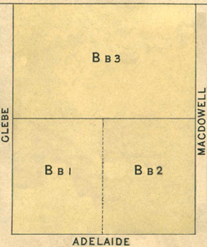
Map 2 - Sections Aa, Bb
The information in these reports provides a timeline of occurrences for each property up to 1919, including details such as conveyances and occupancy. Compiled from records at the Tasmanian Archives, the Land Titles Office, Hobart Town Gazette Valuation Rolls, and newspaper articles, this is a work in progress and will be continually updated.
All sections below have been modified from the Tasmanian Archives: Map - Bothwell (B38), AF819/1/27
View original map on the Tasmanian Archives website https://libraries.tas.gov.au/Digital/AF819-1-27
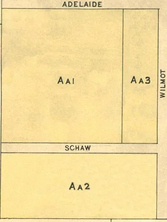
[Aa1] Schaw Street - 16a 0r 0p
Bounded on the West by thirteen chains and thirty-four links southerly along the West boundary of Bothwell township commencing at Adelaide Street; on the South by twelve chains easterly along Schaw Street; on the East by thirteen chains and thirty-four links northerly along Crown land to Adelaide Street aforesaid; and thence on the North by twelve chains westerly along that street to the point of commencement - 16 acres.
Land Grant: 7 Aug 1849, William Moyes, in consideration of £48 (RD1: William Moyes, p200/1849, https:/libraries.tas.gov.au/Digital/RD1-1-23/RD1-1-23P207JPG)
Land Grant: 8 Aug 1849, William Moyes, enrolled upon payment of £48 (RD1: William Moyes, p200/1849, https:/libraries.tas.gov.au/Digital/RD1-1-23/RD1-1-23P207JPG)
Land: 18 May 1858, William Moyes (owner), annual rateable value £8 (TGG: "Valuation Roll," 1858, p698-699, https:/www.familysearch.org/ark:/61903/3:1:3QS7-898F-VZZ3)
Land: 20 Nov 1860, William Moyes (owner), annual rateable value £8 (TGG: "Valuation Roll," 1860, p1882-1883, https:/www.familysearch.org/ark:/61903/3:1:3QS7-L98F-VQGX)
Land: 15 Nov 1864, William Moyes (owner), cultivated land, annual rateable value £8 (TGG: "Valuation Roll," 1864, p2078-2079, https:/www.familysearch.org/ark:/61903/3:1:3QSQ-G98F-V3JQ)
Land: 26 Feb 1867, William Moyes (owner), agricultural land, annual rateable value £8 (TGG: "Valuation Roll," 1867, p468-469, https:/www.familysearch.org/ark:/61903/3:1:3QS7-L98F-V3G3)
Mortgage: 26 Apr 1876, William Moyes borrowed £120 from James Alfred Huybers and William Simmons Hammond (LIST: William Moyes, historic deed, no 06/1778)
Property Transfer: aft 29 Jun 1876, Estate of William Moyes to James Huybers & William Hammond (LIST: William Moyes, historic deed, no 06/1778)
Land: 19 Mar 1878, William Henry Jones (occupier), Moyes Estate (owner), annual rateable value £8 (TGG: "Valuation Roll," 1878, p494-495, https:/www.familysearch.org/ark:/61903/3:1:3QS7-898F-J97X-7)
Conveyed: 19 Sep 1881, James Huybers & William Simmons to William Henry Jones for £100 (LIST: William Henry Jones, historic deed, no 06/9016)
Conveyed: aft 19 Sep 1881, William Henry Jones to William Jonathan Blake for £120 (paid on 19 Jun 1886); a conveyance was never executed (LIST: William Jonathan Blake, historic deed, no 07/6475)
Land: 16 Feb 1886, William Blake (owner), annual rateable value £8 (TGG: "Valuation Roll," 1886, p429, https:/www.familysearch.org/ark:/61903/3:1:3QS7-898F-29B)
Conveyed: 19 Jun 1886, William Jonathan Blake to Arthur Augustus Allen for £120 (LIST: William Jonathan Blake, historic deed, no 07/6475)
Mortgage: 24 Jun 1886, Arthur Augustus Allen borrowed £100 from Elizabeth Dear (LIST: Arthur Augustus Allen, historic deed, no 07/6525)
Land: 28 Mar 1899, Unoccupied, Arthur Allen (owner), capital value £250, annual rateable value £10; includes [A] (TGG: "Valuation Roll," 1899, p326-327, https:/www.familysearch.org/ark:/61903/3:1:3QS7-998F-V4YV)
Conveyed: 10 May 1900, Arthur Augustus Allen to Robert Swindells for £80; paid £19 2s 4p to Elizabeth Dear and £60 17s 8p to Arthur Allen (LIST: Arthur Augustus Allen, historic deed, no 10/1702)
Conveyed: 9 Mar 1909, Robert Swindells to Edward Swindells for £70 (LIST: Robert Swindells, historic deed, no 12/0044)
[Aa2] Wilmot Street - 4a 3r 16p
Bounded on the East by thirteen chains and sixty-one links northerly along Wilmot Street from its angle with Schaw Street; on the North by three chains and fifty-eight links westerly along Adelaide Street; on the West by thirteen chains and fifty links southerly along land purchased from the Crown by William Moyes to Schaw Street aforesaid; and thence on the South by three chains and fifty-eight links easterly along that street to the point of commencement - 4 acres, 3 roods, 16 perches.
Conveyed: 10 Aug 1854, John White purchased Crown Land for £31 7s (CT: "Sale of Crown Lands," 11 Aug 1854, https:/trove.nla.gov.au/newspaper/article/8776918)
Land Grant: 7 Nov 1854, John White, in consideration of £31 7s (RD1: John White, p120/1855, https:/libraries.tas.gov.au/Digital/RD1-1-30/RD1-1-30P120JPG)
Land Grant: 15 Mar 1855, John White, enrolled upon payment of £31 7s (RD1: John White, p120/1855, https:/libraries.tas.gov.au/Digital/RD1-1-30/RD1-1-30P120JPG)
Land: 18 May 1858, John White (owner), 42 acres, annual rateable value £20; includes [A2], [A3], 12a remains unknown (TGG: "Valuation Roll," 1858, p700, https:/www.familysearch.org/ark:/61903/3:1:3QS7-898F-VZH5)
Land: 15 Nov 1864, John White (owner), 30 acres, annual rateable value £12; includes [A2], [A3] (TGG: "Valuation Roll," 1864, p2078-2079, https:/www.familysearch.org/ark:/61903/3:1:3QSQ-G98F-V3JQ)
Land: 26 Feb 1867, John White (owner), 30 acres, annual rateable value £12; includes [A2], [A3] (TGG: "Valuation Roll," 1867, p470-471, https:/www.familysearch.org/ark:/61903/3:1:3QSQ-G98F-VQ9C)
Land: 19 Mar 1878, John White (owner), allotments, 44 acres, annual rateable value £19-10s; includes [2], [A2], [A3], [A10] (TGG: "Valuation Roll," 1878, p496-497, https:/www.familysearch.org/ark:/61903/3:1:3QS7-898F-J97K-M)
Conveyed: 13 Jan 1898, John White to Arthur Augustus Allen for £70 (LIST: Arthur Augustus Allen, historic deed, no 09/8276)
Land: 28 Mar 1899, Unoccupied, Arthur Allen (owner), 26 acres, capital value £250, annual rateable value £10; includes [Aa1] (TGG: "Valuation Roll," 1899, p326-327, https:/www.familysearch.org/ark:/61903/3:1:3QS7-998F-V4YV)
Conveyed: 8 Mar 1909, Arthur Augustus Allen to Edward Swindells for £35; paid £22 8s to Frederick Bowden Rattle and £12 12s to Arthur Allen (LIST: Arthur Augustus Allen, historic deed, no 12/0631)
[Aa3] Schaw Street- 10a 1r 33p
Bounded on the North by fifteen chains and sixty-eight links westerly along Schaw Street from its angle with Wilmot Street; on the West by six chains and sixty-seven links southerly along Crown Land; on the South by fifteen chains and sixty-eight links easterly along land granted to James Scott and Patrick Wood respectively to Wilmot Street aforesaid; and thence on the East by six chains and sixty-seven links northerly along that street to the point of commencement - 10 acres, 1 rood, 33 perches.
Land Grant: 28 Dec 1854, Captain William Langdon, in consideration of £19 (RD1: William Langdon, p66/1855, https:/libraries.tas.gov.au/Digital/RD1-1-30/RD1-1-30P66JPG)
16 Jan 1855 - Deed of Grant enrolled and recorded to William Langdon upon receipt of £19 duly paid to the crown.
Land: 15 Nov 1864, William Langdon (owner), allotments, 12 acres, annual rateable value £3; includes [Ss1]
Land: 26 Feb 1867, William Langdon (owner), allotments, 12 acres, annual rateable value £3; includes [Ss1] (TGG: "Valuation Roll," 1867, p468-469, https:/www.familysearch.org/ark:/61903/3:1:3QS7-L98F-V3G3)
Land: 11 Feb 1868, William Langdon (owner), allotments, 12 acres, annual rateable value £3; includes [Ss1] (TGG: "Valuation Roll," 1868, p224-225, https:/www.familysearch.org/ark:/61903/3:1:3QS7-898F-JT5Z)
Land: 7 Feb 1871, William Langdon (owner), allotments, 12 acres, annual rateable value £3; includes [Ss1] (TGG: "Valuation Roll," 1871, p186-187, https:/www.familysearch.org/ark:/61903/3:1:3QS7-L98F-KSSD)
Land: 19 Mar 1878, William Langdon (owner), allotments, 12 acres, annual rateable value £3; includes [Ss1] (TGG: "Valuation Roll," 1878, p494-495, https:/www.familysearch.org/ark:/61903/3:1:3QS7-898F-J97X-7)
Property Transfer: 14 Jul 1879, [Aa3] Wilmot St, Bothwell, TAS; Estate of Captain William Langdon to his son, William Langdon (PROB: William Langdon, No 2225/1879, https:/libraries.tas.gov.au/Digital/AD960-1-13-2225)
Land: 28 Mar 1899, Unoccupied, William Langdon (owner), land, 12 acres, capital value £50, annual rateable value £2; includes [Ss1] (TGG: "Valuation Roll," 1899, p326-327, https:/www.familysearch.org/ark:/61903/3:1:3QS7-998F-V4YV)
[Bb1-Bb2] Adelaide Street - 10a 1r 6p
Bounded on the South by twelve chains and sixty-four links easterly along Adelaide Street from its angle with Glebe Street; on the East by eight chains and fourteen links northerly along Macdowall Street; on the North by twelve chains and sixty-four links westerly along an allotment purchased from the Crown by William Chester to Glebe Street aforesaid; and thence on the West y eight chains and fourteen links southerly along that street to the point of commencement - 10 acres, 1 rood, 6 perches.
Conveyed: 10 Aug 1854, Charles William Lewis purchased Crown Land for £48 (CT: "Sale of Crown Lands," 11 Aug 1854, https:/trove.nla.gov.au/newspaper/article/8776918)
Land Grant: 19 Dec 1854, Charles William Lewis, in consideration of £48 (RD1: Charles William Lewis, p155/1855, https:/libraries.tas.gov.au/Digital/RD1-1-30/RD1-1-30P155JPG)
Land Grant: 19 Apr 1855, Charles William Lewis, enrolled upon payment of £48 (RD1: Charles William Lewis, p155/1855, https:/libraries.tas.gov.au/Digital/RD1-1-30/RD1-1-30P155JPG)
Conveyed: bef 20 Nov 1860, Charles William Lewis to Richard Wyatt; a deed has not been located (TGG: "Valuation Roll," 1860, p1884-1885, https:/www.familysearch.org/ark:/61903/3:1:3QS7-L98F-VQYQ)
Land: 20 Nov 1860, Richard Wyatt (owner), annual rateable value £5 (TGG: "Valuation Roll," 1860, p1884-1885, https:/www.familysearch.org/ark:/61903/3:1:3QS7-L98F-VQYQ)
Land: 15 Nov 1864, Richard Wyatt (owner), allotment, annual rateable value £1 (TGG: "Valuation Roll," 1864, p2080, https:/www.familysearch.org/ark:/61903/3:1:3QS7-998F-VS46)
Land: 26 Feb 1867, Richard Wyatt (owner), allotment, annual rateable value £3 (TGG: "Valuation Roll," 1867, p470-471, https:/www.familysearch.org/ark:/61903/3:1:3QSQ-G98F-VQ9C)
Land: 11 Feb 1868, Richard Wyatt (owner), allotment, annual rateable value £3 (TGG: "Valuation Roll," 1868, p226-227, https:/www.familysearch.org/ark:/61903/3:1:3QS7-898F-JTLY)
Land: 19 Mar 1878, Nathaniel Paul Allison (occupier), Richard Wyatt (owner), paddock, , annual rateable value £5 (TGG: "Valuation Roll," 1878, p493, https:/www.familysearch.org/ark:/61903/3:1:3QS7-898F-J97V-D)
Land: 14 Jan 1890, Richard Wyatt (owner), annual rateable value £4 (TGG: "Valuation Roll," 1890, p176-177, https:/www.familysearch.org/ark:/61903/3:1:3QS7-898F-VD2J)
Conveyed: 4 Aug 1891, Charles William Lewis & Richard Wyatt to Gifford White for £50 paid to Richard Wyatt; plus 5s paid to Charles William Lewis (LIST: Gifford White, historic deed, no 08/8630)
Land: 16 Feb 1892, Gifford White Jnr (owner), annual rateable value £4 (TGG: "Valuation Roll," 1892, p480-481, https:/www.familysearch.org/ark:/61903/3:1:3QS7-998F-VGXZ)
Land: 28 Mar 1899, Vincent Geard (occupier), Gifford White (owner), paddock, capital value £50, annual rateable value £2 (TGG: "Valuation Roll," 1899, p324-325, https:/www.familysearch.org/ark:/61903/3:1:3QSQ-G98F-V8FR)
Conveyed: 17 Jun 1904, Gifford White to Vincent Geard for £60 (LIST: Gifford White, historic deed, no 10/9638)
[Bb3] Glebe Street - 10a 0r 0p
Bounded on the North by twelve chains and fifty links easterly along a location to Alexander Reid commencing at Glebe St; on the East by eight chains southerly along Crown Land; on the South by twelve chains and fifty links westerly also along Crown Land to Glebe St; thence on the West by eight chains northerly along that street to the point of commencement - 10 acres.
Land Grant: 2 Oct 1846, William Chester, in consideration of £30 (RD1: William Chester, p64/1846, https:/libraries.tas.gov.au/Digital/RD1-1-21/RD1-1-21P64JPG)
Land Grant: 20 Oct 1846, William Chester, enrolled upon payment of £30 (RD1: William Chester, p64/1846, https:/libraries.tas.gov.au/Digital/RD1-1-21/RD1-1-21P64JPG)
Conveyed: bef 18 May 1858, William Chester to James Fisher; a deed has not been located (TGG: "Valuation Roll," 1858, p696-697, https:/www.familysearch.org/ark:/61903/3:1:3QS7-L98F-VZVR)
Land: 18 May 1858, Richard Allen, (occupier), James Fisher (owner), partly cultivated, annual rateable value £5 (TGG: "Valuation Roll," 1858, p696-697, https:/www.familysearch.org/ark:/61903/3:1:3QS7-L98F-VZVR)
Advertisement: 30 Nov 1858, "Auction" Chesterfield (COUR: "Valuable Properties," Fisher 30 Nov 1858, https:/trove.nla.gov.au/newspaper/article/2465436)
Conveyed: bef 19 Nov 1861, Executors of James Fisher to Richard Allen; a deed has not been located (TGG: "Valuation Roll," 1861, p1693, https:/www.familysearch.org/ark:/61903/3:1:3QSQ-G98F-J9Q6-B)
Land: 19 Nov 1861, Richard Allen (owner), annual rateable value £5 (TGG: "Valuation Roll," 1861, p1693, https:/www.familysearch.org/ark:/61903/3:1:3QSQ-G98F-J9Q6-B)
Land: 17 Nov 1863, Richard Allen (owner), cultivated, annual rateable value £5; includes [H7-H8] (TGG: "Valuation Roll," 1863, p2127, https:/www.familysearch.org/ark:/61903/3:1:3QS7-998F-V998-H)
Land: 26 Feb 1867, Richard Allen (owner), agricultural land, annual rateable value £5 (TGG: "Valuation Roll," 1867, p465, https:/www.familysearch.org/ark:/61903/3:1:3QS7-998F-VS6C)
Land: 19 Mar 1878, Richard Allen (owner), arable, 41 acres, annual rateable value £20 10s; includes [Mm], [Oo1-part] (TGG: "Valuation Roll," 1878, p493, https:/www.familysearch.org/ark:/61903/3:1:3QS7-898F-J97V-D)
Property Transfer: 27 Nov 1882, Estate of Richard Allen to his son, Arthur Augustus Allen (PROB: Richard Allen, no 2621/1882, https:/libraries.tas.gov.au/Digital/AD960-1-12-2621)
Certificate of Title: 10 Dec 1891, registered to Arthur Augustus Allen, farmer (LIST: Arthur Augustus Allen, title historic, fol 81, vol 90)
Residence: 16 Feb 1892, George Horne (occupier), Arthur Allen (owner), house, annual rateable value £15 (TGG: "Valuation Roll," 1892, p478-479, https:/www.familysearch.org/ark:/61903/3:1:3QS7-898F-V99C-K)
Land: 28 Mar 1899, William Henry Sealy (occupier), Arthur Allen (owner), paddock, capital value £100, annual rateable value £4 (TGG: "Valuation Roll," 1899, p326-327, https:/www.familysearch.org/ark:/61903/3:1:3QS7-998F-V4YV)
Conveyed: 30 Dec 1899, Arthur Augustus Allen to William Henry Sealy for £40 (LIST: William Henry Sealy, title historic, vol 114, fol 94)
Certificate of Title: 30 Jan 1900, registered to William Henry Sealy, storekeeper (LIST: William Henry Sealy, title historic, vol 114, fol 94)
Conveyed: 10 Mar 1917, William Henry Sealy to John Augustus Jeffries (LIST: William Henry Sealy, title historic, vol 114, fol 94)
Bibliography of Sources
COUR - TROVE: The Courier (Hobart, TAS : 1840-1859). Images. National Library of Australia. https://trove.nla.gov.au : 2023.
CT - TROVE: Colonial Times (Hobart, TAS : 1828-1857). Images. National Library of Australia. https://trove.nla.gov.au : 2023.
LIST - Tasmania: The List: Properties & Titles. Historic Deeds, Grants & Titles. Images. Land Information System Tasmania. Tasmanian Government. Australia. https://www.thelist.tas.gov.au : 2023.
PROB - Libraries Tasmania: Copies of Wills Recording Granting of Probate, 1825-1989 (AD960). Images. Probate Registry (TA1574). Tasmanian Government, Australia. https://www.libraries.tas.gov.au/tasmanian-archives : 2023.
RD1 - Libraries Tasmania: Deeds of Land Grants 1832-1935 (RD1). Images. Registry of Deeds (TA84). Tasmanian Government, Australia. https://libraries.tas.gov.au/tasmanian-archives : 2023.
TGG - FamilySearch: Australia, Tasmania, Government Gazette, 1833-1925. Images. Tasmanian Archive and Heritage Office, Hobart. https://www.familysearch.org/search/collection/2170647 : 2023.