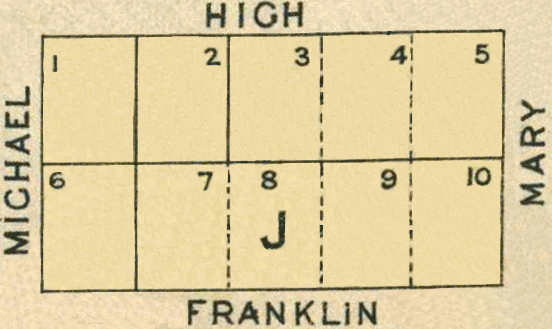
Map 1 - Section J
The information in these reports provides a timeline of occurrences for each property up to 1919, including details such as conveyances and occupancy. Compiled from records at the Tasmanian Archives, the Land Titles Office, Hobart Town Gazette Valuation Rolls, and newspaper articles, this is a work in progress and will be continually updated.
All map sections below have been modified from the Tasmanian Archives: Map - Bothwell B37, AF819/1/26
View original map on the Tasmanian Archives website https://libraries.tas.gov.au/Digital/AF819-1-26
[J1] High Street - 0a 1r 33p
Bounded on the North by one chain and eighty-two links easterly along High Street from its angle with Michael Street; on the East by two chains fifty-one links and one-half link southerly along Lot 2; on the South by one chain and eighty-two links westerly along Lot 6 to Michael Street aforesaid; and thence on the West by two chains fifty-one links and one-half link northerly along that street to the point of commencement - 1 rood, 33 perches.
Conveyed: 18 Apr 1855, John Morris Colbeck purchased Crown Land for £30 (CT: "Sale of Crown Lands," 19 Apr 1855, https:/trove.nla.gov.au/newspaper/article/8779986)
Land Grant: 20 Jun 1856, John Morris Colbeck, granted in consideration of £30 (RD1: John Morris Colbeck, p186/1856, https:/libraries.tas.gov.au/Digital/RD1-1-34/RD1-1-34P185JPG)
Land Grant: 23 Jul 1856, John Morris Colbeck, enrolled upon payment of £30 (RD1: John Morris Colbeck, p186/1856, https:/libraries.tas.gov.au/Digital/RD1-1-34/RD1-1-34P185JPG)
Land: 18 May 1858, John Morris Colbeck (owner), 3½ acres, annual rateable value £5; includes [J3-J5], [K5-K7] (TGG: "Valuation Roll," 1858, p696-697, https:/www.familysearch.org/ark:/61903/3:1:3QS7-L98F-VZVR)
Land: 26 Feb 1867, John Morris Colbeck (owner), 3½ acres, annual rateable value £6; includes [J3-J5], [K5-K7] (TGG: "Valuation Roll," 1867, p466-467, https:/www.familysearch.org/ark:/61903/3:1:3QS7-898F-V3LK)
Land: 1 Mar 1870, John Morris Colbeck (owner), 3½ acres, annual rateable value £6; includes [J3-J5], [K5-K7] (TGG: "Valuation Roll," 1870, p356-357, https:/www.familysearch.org/ark:/61903/3:1:3QS7-L98F-VB3M)
Land: 7 Feb 1871, John Morris Colbeck (owner), 3½ acres, annual rateable value £2 10s; includes [J3-J5], [K5-K7] (TGG: "Valuation Roll," 1871, p186-187, https:/www.familysearch.org/ark:/61903/3:1:3QS7-L98F-KSSD)
Advertisement: 30 Apr 1874, "Allotments at Bothwell" (MERC: "Allotments at Bothwell," 30 Apr 1874, https:/trove.nla.gov.au/newspaper/article/8929643)
Advertisement: 16 Mar 1878, "Bothwell Stock Sale" Allotments (MERC: "Bothwell Stock Sale," 16 Mar 1878, https:/trove.nla.gov.au/newspaper/article/8961100)
Conveyed: abt 1879, John Morris Colbeck to Robert Bonney for £10 (paid on 13 Feb 1899); a conveyance was never executed (LIST: Robert Bonney, historic deed, no 09/9916)
Land: 14 Jan 1890, Robert Bonney (owner), annual rateable value 10s (TGG: "Valuation Roll," 1890, p174-175, https:/www.familysearch.org/ark:/61903/3:1:3QS7-L98F-VD5K)
Conveyed: 13 Feb 1899, Robert Bonney to Charles William Craig for £14 (LIST: Robert Bonney, historic deed, no 09/9916)
Land: 28 Mar 1899, Mrs Julia Craig (occupier), Charles William Craig (owner), allotment, capital value £16 (TGG: "Valuation Roll," 1899, p324-325, https:/www.familysearch.org/ark:/61903/3:1:3QSQ-G98F-V8FR)
Conveyed: 27 Apr 1912, Charles Craig to Robert Edward Blake for £15 (LIST: Charles Craig, historic deed, no 12/7283)
Land: 3 Nov 1914, Robert Edward Blake (owner), annual rateable value £2; includes [J2] (TGG: "Valuation Roll," 1914, p2008-2009, https:/www.familysearch.org/ark:/61903/3:1:3QS7-L98N-977Y)
Land: 4 Mar 1919, Robert Edward Blake (owner), annual rateable value £2; includes [J2] (TGG: "Valuation Roll," 1919, p492-493, https:/www.familysearch.org/ark:/61903/3:1:3QS7-898N-SQ1F)
[J2] High Street - 0a 1r 33p
Bounded on the West by two chains fifty-one links and one half link Southerly along Lot 1 commencing at the North-East angle thereof on High Street; on the South by one chain and eighty-two links Easterly along Lot 7; on the East by two chains fifty-one links and one half link Northerly along Lot 3 to High Street aforesaid; and thence on the North by one chain and eighty-two links Westerly along that street to the point of commencement - 1 rood, 33 perches.
Conveyed: 18 Apr 1855, Thomas Hale purchased Crown Land for £24 (CT: "Sale of Crown Lands," 19 Apr 1855, https:/trove.nla.gov.au/newspaper/article/8779986)
Land Grant: 20 Jun 1855, Thomas Hale, granted in consideration of £24 (RD1: Thomas Hale, p104/1856, https:/libraries.tas.gov.au/Digital/RD1-1-31/RD1-1-31P104JPG)
Land Grant: 29 Jun 1855, Thomas Hale, enrolled upon payment of £24 (RD1: Thomas Hale, p104/1856, https:/libraries.tas.gov.au/Digital/RD1-1-31/RD1-1-31P104JPG)
Land: 18 May 1858, Thomas Hale (owner), 4½ acres, annual rateable value £15; includes [I7-I9] (TGG: "Valuation Roll," 1858, p696-697, https:/www.familysearch.org/ark:/61903/3:1:3QS7-L98F-VZVR)
Land: 20 Nov 1860, Thomas Hale (owner), 4½ acres, annual rateable value £16; includes [I7-I9] (TGG: "Valuation Roll," 1860, p1882-1883, https:/www.familysearch.org/ark:/61903/3:1:3QS7-L98F-VQGX)
Land: 19 Nov 1861, Thomas Hale (owner), 4½ acres, annual rateable value £16; includes [I7-I9] (TGG: "Valuation Roll," 1861, p1694-1695, https:/www.familysearch.org/ark:/61903/3:1:3QS7-898F-J93K-Z)
Conveyed: bef 29 Jun 1863, Thomas Hale to James Taylor; a deed has not been located (LIST: James Taylor, title historic, vol 2, fol 64)
Certificate of Title: 29 Jun 1863, registered to James Taylor, miller (LIST: James Taylor, title historic, vol 2, fol 64)
Land: 17 Nov 1863, James Taylor (owner), allotment, annual rateable value £2 (TGG: "Valuation Roll," 1863, p2130-2131, https:/www.familysearch.org/ark:/61903/3:1:3QS7-998F-V992-K)
Land: 15 Nov 1864, James Taylor (owner), allotment, annual rateable value £2 (TGG: "Valuation Roll," 1864, p2078-2079, https:/www.familysearch.org/ark:/61903/3:1:3QSQ-G98F-V3JQ)
Land: 26 Feb 1867, James Taylor (owner), allotment, annual rateable value £2 (TGG: "Valuation Roll," 1867, p470-471, https:/www.familysearch.org/ark:/61903/3:1:3QSQ-G98F-VQ9C)
Land: 11 Mar 1873, James Taylor (owner), allotment, annual rateable value £2 (TGG: "Valuation Roll," 1873, p252-253, https:/www.familysearch.org/ark:/61903/3:1:3QS7-L98F-VVQ5)
Land: 19 Mar 1878, James Taylor (owner), allotment, annual rateable value £1 (TGG: "Valuation Roll," 1878, p496-497, https:/www.familysearch.org/ark:/61903/3:1:3QS7-898F-J97K-M)
Conveyed: 13 Mar 1886, James Taylor to Charles William Craig for £15 (LIST: James Taylor, title historic, vol 2, fol 64)
Certificate of Title: 2 Jun 1886, registered to Charles William Craig, labourer (LIST: Charles William Craig, title historic, vol 52, fol 64)
Land: 21 Feb 1888, Charles William Craig (owner), annual rateable value 5s (TGG: "Valuation Roll," 1888, p400-401, https:/www.familysearch.org/ark:/61903/3:1:3QS7-L98F-JLTX)
Land: 14 Jan 1890, Charles William Craig (owner), annual rateable value 10s (TGG: "Valuation Roll," 1890, p174-175, https:/www.familysearch.org/ark:/61903/3:1:3QS7-L98F-VD5K)
Land: 28 Mar 1899, Charles Craig (owner), capital value £40, annual rateable value £2; includes [J6-J9-part] (TGG: "Valuation Roll," 1899, p324-325, https:/www.familysearch.org/ark:/61903/3:1:3QSQ-G98F-V8FR)
Conveyed: 15 May 1912, Charles Craig to Robert Edward Blake (LIST: Charles William Craig, title historic, vol 52, fol 64)
Land: 3 Nov 1914, Robert Edward Blake (owner), annual rateable value £2; includes [J1] (TGG: "Valuation Roll," 1914, p2008-2009, https:/www.familysearch.org/ark:/61903/3:1:3QS7-L98N-977Y)
Land: 4 Mar 1919, Robert Edward Blake (owner), annual rateable value £2; includes [J1] (TGG: "Valuation Roll," 1919, p492-493, https:/www.familysearch.org/ark:/61903/3:1:3QS7-898N-SQ1F)
[J3-J5] High Street - 1a 1r 19p
Bounded on the North by five chains and forty-six links westerly along High Street from its angle with Mary Street; on the West by two chains fifty-one links and on half link southerly along Lot 2; on the South by five chains and forty-six links easterly along Lots 8, 9 and 10 to Mary Street aforesaid; and thence on the East by two chains fifty-one links and on half link northerly along that street to the point of commencement - 1 acre, 1 rood, 19 perches.
Conveyed: 18 Apr 1855, John Morris Colbeck purchased Crown Land for £64 (CT: "Sale of Crown Lands," 19 Apr 1855, https:/trove.nla.gov.au/newspaper/article/8779986)
Land Grant: 18 Jun 1856, John Morris Colbeck, in consideration of £64 (RD1: John Morris Colbeck, p185/1856, https:/libraries.tas.gov.au/Digital/RD1-1-34/RD1-1-34P184JPG)
Land Grant: 23 Jul 1856, John Morris Colbeck, enrolled, upon payment of £64 (RD1: John Morris Colbeck, p185/1856, https:/libraries.tas.gov.au/Digital/RD1-1-34/RD1-1-34P184JPG)
Land: 18 May 1858, John Morris Colbeck (owner), 3½ acres, annual rateable value £5; includes [J1], [K5-K7] (TGG: "Valuation Roll," 1858, p696-697, https:/www.familysearch.org/ark:/61903/3:1:3QS7-L98F-VZVR)
Land: 26 Feb 1867, John Morris Colbeck (owner), 3½ acres, annual rateable value £6; includes [J1], [K5-K7] (TGG: "Valuation Roll," 1867, p466-467, https:/www.familysearch.org/ark:/61903/3:1:3QS7-898F-V3LK)
Land: 7 Feb 1871, John Morris Colbeck (owner), 3½ acres, annual rateable value £2 10s; includes [J1], [K5-K7] (TGG: "Valuation Roll," 1871, p186-187, https:/www.familysearch.org/ark:/61903/3:1:3QS7-L98F-KSSD)
Advertisement: 30 Apr 1874, "Allotments at Bothwell" (MERC: "Allotments at Bothwell," 30 Apr 1874, https:/trove.nla.gov.au/newspaper/article/8929643)
Advertisement: 16 Mar 1878, "Bothwell Stock Sale" Allotments (MERC: "Bothwell Stock Sale," 16 Mar 1878, https:/trove.nla.gov.au/newspaper/article/8961100)
Conveyed: bef 14 May 1879, John Morris Colbeck to Isaac Blake; a deed has not been located (LIST: Isaac Blake, title historic, vol 26, fol 21)
Certificate of Title: 14 May 1879, registered to Isaac Blake (LIST: Isaac Blake, title historic, vol 26, fol 21)
Conveyed: 13 Dec 1888, Isaac Blake to William James Westell for £40 (LIST: Isaac Blake, title historic, vol 26, fol 21)
Certificate of Title: 19 Dec 1888, registered to William James Westell, shepherd (LIST: William Westell, title historic, vol 26, fol 21)
Residence: 14 Jan 1890, Richard Bowden (occupier), William Westell (owner), house, annual rateable value £15 (TGG: "Valuation Roll," 1890, p173, https:/www.familysearch.org/ark:/61903/3:1:3QS7-898F-VDGQ)
Residence: 28 Mar 1899, Unoccupied, William Westell (owner), house, capital value £250, annual rateable value £15; includes [L5, L10] (TGG: "Valuation Roll," 1899, p326-327, https:/www.familysearch.org/ark:/61903/3:1:3QS7-998F-V4YV)
Residence: 3 Nov 1914, William James Westell (owner, occupier), house, annual rateable value £15 (TGG: "Valuation Roll," 1914, p2010-2011, https:/www.familysearch.org/ark:/61903/3:1:3QS7-L98N-974D)
Conveyed: 17 Feb 1917, William James Westell to James David Brazendale for £300 (LIST: William Westell, title historic, vol 26, fol 21)
Certificate of Title: 2 Mar 1917, registered to James David Brazendale, pastoralist, Berriedale (LIST: James Brazendale the Younger, historic title, vol 246, fol 142)
Electoral Roll: 1919, James David Brazendale, labourer (ELEC: p2-3/1919, https:/www.ancestry.com.au/imageviewer/collections/1207/images/RDAUS1901_100682__0007-00929)
Residence: 4 Mar 1919, James Brazendale Jnr (owner, occupier), cottage, annual rateable value £20 (TGG: "Valuation Roll," 1919, p492-493, https:/www.familysearch.org/ark:/61903/3:1:3QS7-898N-SQ1F)
[J6-10] Franklin Street - 2a 1r 5p
[J6] - Bounded on the South by one chain and eighty-two links along Franklin Street from its angle with Michael Street; on the East by two chains fifty-one links and one half link northerly along Lot 7; on the North by one chain and eighty-two links westerly along Lot 1 to Michael Street; and thence on the West by two chains fifty-one links and one half link southerly along that street to the point of commencement - 1 rood, 33 perches.
[J7-J10] - Bounded on the South by seven chains and twenty-eight links westerly along Franklin Street from its angle with Mary Street; on the West by two chains fifty-one links and one half link northerly along Lot 6; on the North by seven chains and twenty-eight links easterly along Lots 2, 3, 4 and 5 to Mary Street; and thence on the East by two chains fifty-one links and one half link southerly along that street to the point of commencement - 1 acre, 3 roods, 12 perches.
Conveyed: 18 Apr 1855, [J6], Eli Parker purchased Crown Land for £22 (CT: "Sale of Crown Lands," 19 Apr 1855, https:/trove.nla.gov.au/newspaper/article/8779986)
Conveyed: 18 Apr 1855, [J7-J10], John Bale purchased Crown Land for £79 (CT: "Sale of Crown Lands," 19 Apr 1855, https:/trove.nla.gov.au/newspaper/article/8779986)
Land Grant: 20 Jun 1855, [J6], Eli Parker, in consideration of £22 (RD1: Eli Parker, p118/1855, https:/libraries.tas.gov.au/Digital/RD1-1-31/RD1-1-31P118JPG)
Land Grant: 20 Jun 1855, [J7-J10], John Bale, in consideration of £79 (RD1: John Bale, p119/1855, https:/libraries.tas.gov.au/Digital/RD1-1-31/RD1-1-31P119JPG)
Land Grant: 3 Jul 1855, [J6], Eli Parker, enrolled upon payment of £22 (RD1: Eli Parker, p118/1855, https:/libraries.tas.gov.au/Digital/RD1-1-31/RD1-1-31P118JPG)
Land Grant: 4 Jul 1855, [J7-J10], John Bale, enrolled upon payment of £79 (RD1: John Bale, p119/1855, https:/libraries.tas.gov.au/Digital/RD1-1-31/RD1-1-31P119JPG)
Conveyed: 31 Jul 1857, [J6], Eli Parker to John Bale for £20 (LIST: Eli Parker, historic deed, no 04/4622)
Land: 18 May 1858, John Bale (owner), cultivated, annual rateable value £2 (TGG: "Valuation Roll," 1858, p696-697, https:/www.familysearch.org/ark:/61903/3:1:3QS7-L98F-VZVR)
Land: 19 Nov 1861, John Bale (owner), cultivated, annual rateable value £2 (TGG: "Valuation Roll," 1861, p1693, https:/www.familysearch.org/ark:/61903/3:1:3QSQ-G98F-J9Q6-B)
Land: 26 Feb 1867, John Bale (owner), cultivated, annual rateable value £2 (TGG: "Valuation Roll," 1867, p466-467, https:/www.familysearch.org/ark:/61903/3:1:3QS7-898F-V3LK)
Advertisement: 27 Jan 1870, John Bale named under "Real Property Act Notices" (MERC: "Real Property Act Notices," 7 Jan 1870, https:/trove.nla.gov.au/newspaper/article/8864563)
Conveyed: aft 19 Feb 1870, John Bale to Simon Arnett; a deed has not been located (LIST: Simon Arnett, title historic, vol 10, fol 133)
Land: 1 Mar 1870, Simon Arnett (owner), 5 acres, annual rateable value £5; includes [L8-L9] (TGG: "Valuation Roll," 1870, p355, https:/www.familysearch.org/ark:/61903/3:1:3QS7-L98F-VBWF)
Certificate of Title: 19 Mar 1870, registered to Simon Arnett, storekeeper (LIST: Simon Arnett, title historic, vol 10, fol 133)
Conveyed: 23 Jun 1870, Simon Arnett to Thomas Smith for £85 (LIST: Simon Arnett, title historic, vol 10, fol 133)
Certificate of Title: 19 Jul 1870, registered to Thomas Smith, shepherd (LIST: Thomas Smith, title historic, vol 11, fol 20)
Land: 22 Mar 1881, Thomas Smith (owner), paddock, annual rateable value £2 (TGG: "Valuation Roll," 1881, p420-421, https:/www.familysearch.org/ark:/61903/3:1:3QS7-898F-JVS8)
Land: 16 Feb 1886, Thomas Smith (owner), paddock, annual rateable value £1 (TGG: "Valuation Roll," 1886, p432-433, https:/www.familysearch.org/ark:/61903/3:1:3QS7-998F-23D)
Conveyed: 6 Aug 1889, Thomas Smith to Johanna (Hurley) Baker (LIST: Thomas Smith, title historic, vol 11, fol 20)
Certificate of Title: 21 Aug 1889, registered to Johanna (Hurley) Baker, married woman (LIST: Joanna Baker, title historic, vol 69, fol 39a (not accessible on the website)
Residence: 14 Jan 1890, John Baker (owner, occupier), house, shed, annual rateable value £8 (TGG: "Valuation Roll," 1890, p174-175, https:/www.familysearch.org/ark:/61903/3:1:3QS7-L98F-VD5K)
Conveyed: 24 Mar 1891, [J6-J9 part] 1a 2r 14¼p, Johanna (Hurley) Baker to Charles William Craig (LIST: Charles William Craig, title historic, vol 78, fol 74)
For more information, go to [J6-9 part] Franklin St & [J9 part-J10] Franklin St
[J6-J9-part] Franklin Street - 1a 2r 14¼p
Bounded on the South by six hundred and thirty-two links angled with Michael Street; on the East by two chains fifty-one links and one half of a link northerly along other part of Lot 9; on the North by six chains thirty-two links westerly along part of Lot 4 and along Lot 3, 2 and 1 to Michael Street aforesaid; and thence on the West by two chains fifty-one links and one half of a link southerly along that Street to the point of commencement - 1 acre, 2 roods, 14¼ perches.
Conveyed: 24 Mar 1891, Johanna (Hurley) Baker to Charles William Craig (LIST: Charles William Craig, title historic, vol 78, fol 74)
Certificate of Title: 19 May 1891, registered to Charles William Craig, labourer (LIST: Charles William Craig, title historic, vol 78, fol 74)
Land: 28 Mar 1899, Charles Craig (owner), capital value £40, annual rateable value £2; includes [J2] (TGG: "Valuation Roll," 1899, p324-325, https:/www.familysearch.org/ark:/61903/3:1:3QSQ-G98F-V8FR)
Conveyed: 13 Nov 1913, Charles William Craig to Sydney Claude Blake for £40 (LIST: Charles William Craig, title historic, vol 78, fol 74)
Land: 3 Nov 1914, Sydney Claude Blake (owner), annual rateable value £2 (TGG: "Valuation Roll," 1914, p2008-2009, https:/www.familysearch.org/ark:/61903/3:1:3QS7-L98N-977Y)
Land: 4 Mar 1919, Sydney Claude Blake (owner), annual rateable value £2 (TGG: "Valuation Roll," 1919, p492-493, https:/www.familysearch.org/ark:/61903/3:1:3QS7-898N-SQ1F)
[J9-part-J10] Franklin Street - 0a 2r 31p
Bounded on the South by two chains and seventy-eight links along Franklin Street from its angle with Mary Street; on the West by two chains fifty-one links and one-half link northerly along the other section of Lot 9; on the North by two chains and seventy-eight links easterly along Lot 4 and 5 to Mary Street; and thence on the East by two chains fifty-one links and one-half link southerly along that street to the point of commencement - 2 roods, 31 perches.
Certificate of Title: 26 May 1891, registered to Johanna (Hurley) Baker, married woman (LIST: Joanna Baker, title historic, vol 69, fol 39a; not accessible on the website)
Conveyed: 4 May 1897, Johanna (Hurley) Baker to John Glover (LIST: John Glover, title historic, vol 102, fol 161)
Certificate of Title: 13 May 1897, registered to John Glover, shepherd (LIST: John Glover, title historic, vol 102, fol 161)
Residence: 28 Mar 1899, Mrs Mary Wells (occupier), John Glover (owner), cottage, capital value £100, annual rateable value £5 (TGG: "Valuation Roll," 1899, p328-329, https:/www.familysearch.org/ark:/61903/3:1:3QS7-L98F-VDMC)
Conveyed: 1 Feb 1912, John Glover to Joseph William Best for £85 (LIST: John Glover, title historic, vol 102, fol 161)
Certificate of Title: 14 Feb 1912, registered to Joseph William Best, labourer (LIST: Joseph William Best, historic title, vol 199, fol 151)
Conveyed: 3 Dec 1914, Joseph William Best to his nephew, George Thomas Manning, for £100 (LIST: Joseph William Best, historic title, vol 199, fol 151)
Certificate of Title: 15 Dec 1914, registered to George Thomas Manning, labourer (LIST: George Thomas Manning, historic title, vol 228, fol 71)
Bibliography of Sources
CT - TROVE: Colonial Times (Hobart, TAS : 1828-1857). Images. National Library of Australia. https://trove.nla.gov.au : 2023.
ELEC - ancestry: Australia, Electoral Rolls, 1903-1980. Images. Australian Electoral Commission, [Electoral Roll]. https://www.ancestry.com.au/search/collections/1207 : 2023.
LIST - Tasmania: The List: Properties & Titles. Historic Deeds, Grants & Titles. Images. Land Information System Tasmania. Tasmanian Government. Australia. https://www.thelist.tas.gov.au : 2023.
MERC - TROVE: The Mercury (Hobart, TAS : 1860-1954). Images. National Library of Australia. https://trove.nla.gov.au : 2023.
RD1 - Libraries Tasmania: Deeds of Land Grants 1832-1935 (RD1). Images. Registry of Deeds (TA84). Tasmanian Government, Australia. https://libraries.tas.gov.au/tasmanian-archives : 2023.
TGG - FamilySearch: Australia, Tasmania, Government Gazette, 1833-1925. Images. Tasmanian Archive and Heritage Office, Hobart. https://www.familysearch.org/search/collection/2170647 : 2023.